You are here: Home > Network List > TA - USArray Transportable Network (new EarthScope stations) Stations List
> Station O25A Wiggins, CO, USA > Earthquake Result Viewer
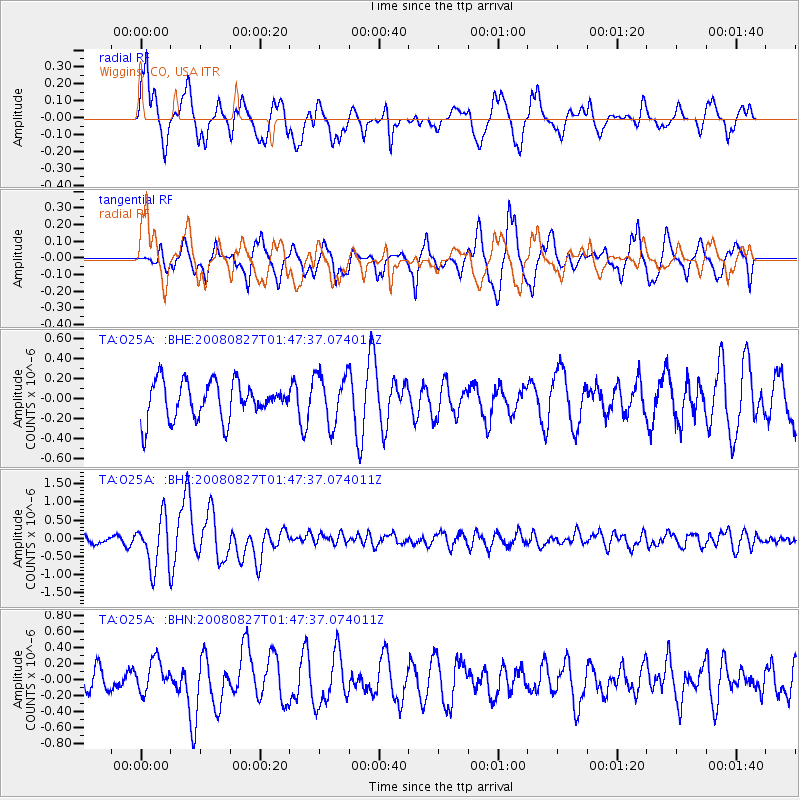
O25A Wiggins, CO, USA - Earthquake Result Viewer
*The percent match for this event was below the threshold and hence no stack was calculated.
| Earthquake location: |
Lake Baykal Region, Russia |
| Earthquake latitude/longitude: |
51.6/104.2 |
| Earthquake time(UTC): |
2008/08/27 (240) 01:35:32 GMT |
| Earthquake Depth: |
16 km |
| Earthquake Magnitude: |
5.8 MB, 6.2 MS, 6.2 MW, 6.2 MW |
| Earthquake Catalog/Contributor: |
WHDF/NEIC |
|
| Network: |
TA USArray Transportable Network (new EarthScope stations) |
| Station: |
O25A Wiggins, CO, USA |
| Lat/Lon: |
40.11 N/104.12 W |
| Elevation: |
1444 m |
|
| Distance: |
85.4 deg |
| Az: |
21.377 deg |
| Baz: |
342.758 deg |
| Ray Param: |
$rayparam |
*The percent match for this event was below the threshold and hence was not used in the summary stack. |
|
| Radial Match: |
67.55373 % |
| Radial Bump: |
400 |
| Transverse Match: |
69.73732 % |
| Transverse Bump: |
400 |
| SOD ConfigId: |
2504 |
| Insert Time: |
2010-03-06 21:09:08.071 +0000 |
| GWidth: |
2.5 |
| Max Bumps: |
400 |
| Tol: |
0.001 |
|
Signal To Noise
| Channel | StoN | STA | LTA |
| TA:O25A: :BHZ:20080827T01:47:37.074011Z | 3.7038994 | 6.9160353E-7 | 1.8672308E-7 |
| TA:O25A: :BHN:20080827T01:47:37.074011Z | 1.1118565 | 1.9727324E-7 | 1.774269E-7 |
| TA:O25A: :BHE:20080827T01:47:37.074011Z | 1.3575454 | 2.5001435E-7 | 1.8416647E-7 |
| Arrivals |
| Ps | |
| PpPs | |
| PsPs/PpSs | |


