You are here: Home > Network List > TS - TERRAscope (Southern California Seismic Network) Stations List
> Station DGR Domenigoni Valley Reservior, California, USA > Earthquake Result Viewer
DGR Domenigoni Valley Reservior, California, USA - Earthquake Result Viewer
| Earthquake location: |
Kermadec Islands Region |
| Earthquake latitude/longitude: |
-31.8/-179.4 |
| Earthquake time(UTC): |
1997/05/03 (123) 16:46:02 GMT |
| Earthquake Depth: |
108 km |
| Earthquake Magnitude: |
6.6 MB, 6.9 UNKNOWN, 6.8 ME |
| Earthquake Catalog/Contributor: |
WHDF/NEIC |
|
| Network: |
TS TERRAscope (Southern California Seismic Network) |
| Station: |
DGR Domenigoni Valley Reservior, California, USA |
| Lat/Lon: |
33.65 N/117.01 W |
| Elevation: |
700 m |
|
| Distance: |
87.7 deg |
| Az: |
47.701 deg |
| Baz: |
229.032 deg |
| Ray Param: |
0.042908948 |
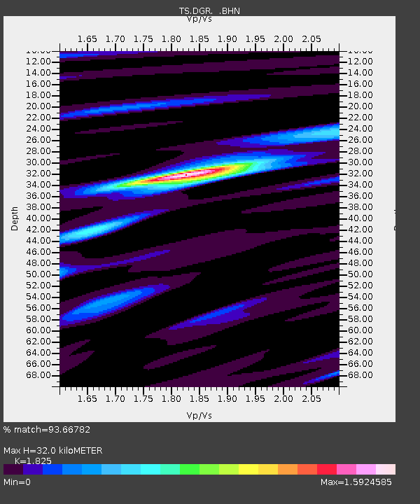
| Estimated Moho Depth: |
32.0 km |
| Estimated Crust Vp/Vs: |
1.83 |
| Assumed Crust Vp: |
6.264 km/s |
| Estimated Crust Vs: |
3.432 km/s |
| Estimated Crust Poisson's Ratio: |
0.29 |
|
| Radial Match: |
93.66782 % |
| Radial Bump: |
317 |
| Transverse Match: |
92.088905 % |
| Transverse Bump: |
357 |
| SOD ConfigId: |
6273 |
| Insert Time: |
2010-02-26 14:09:33.298 +0000 |
| GWidth: |
2.5 |
| Max Bumps: |
400 |
| Tol: |
0.001 |
|

Signal To Noise
| Channel | StoN | STA | LTA |
| TS:DGR: :BHN:19970503T16:58:07.379028Z | 5.254028 | 1.3814047E-6 | 2.6292298E-7 |
| TS:DGR: :BHE:19970503T16:58:07.379028Z | 15.057924 | 1.630692E-6 | 1.0829461E-7 |
| TS:DGR: :BHZ:19970503T16:58:07.379028Z | 23.598877 | 6.5283684E-6 | 2.7663893E-7 |
| Arrivals |
| Ps | 4.3 SECOND |
| PpPs | 14 SECOND |
| PsPs/PpSs | 18 SECOND |


