You are here: Home > Network List > PF - Volcanologic Network of Piton de Fournaise-OVPF Stations List
> Station GPS Grandes Pentes Sud > Earthquake Result Viewer
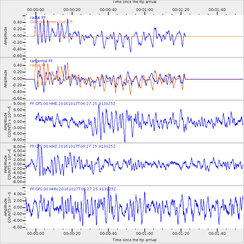
GPS Grandes Pentes Sud - Earthquake Result Viewer
*The percent match for this event was below the threshold and hence no stack was calculated.
| Earthquake location: |
New Britain Region, P.N.G. |
| Earthquake latitude/longitude: |
-6.1/148.9 |
| Earthquake time(UTC): |
2016/10/17 (291) 06:14:58 GMT |
| Earthquake Depth: |
35 km |
| Earthquake Magnitude: |
6.9 MO |
| Earthquake Catalog/Contributor: |
NEIC PDE/NEIC ALERT |
|
| Network: |
PF Volcanologic Network of Piton de Fournaise-OVPF |
| Station: |
GPS Grandes Pentes Sud |
| Lat/Lon: |
21.27 S/55.76 E |
| Elevation: |
1004 m |
|
| Distance: |
90.7 deg |
| Az: |
248.658 deg |
| Baz: |
96.725 deg |
| Ray Param: |
$rayparam |
*The percent match for this event was below the threshold and hence was not used in the summary stack. |
|
| Radial Match: |
62.723236 % |
| Radial Bump: |
400 |
| Transverse Match: |
56.672607 % |
| Transverse Bump: |
385 |
| SOD ConfigId: |
1634031 |
| Insert Time: |
2016-10-31 06:19:11.858 +0000 |
| GWidth: |
2.5 |
| Max Bumps: |
400 |
| Tol: |
0.001 |
|
Signal To Noise
| Channel | StoN | STA | LTA |
| PF:GPS:00:HHZ:20161017T06:27:25.913025Z | 5.3931594 | 4.1706635E-6 | 7.733247E-7 |
| PF:GPS:00:HHN:20161017T06:27:25.913025Z | 1.4948316 | 2.1382373E-6 | 1.4304203E-6 |
| PF:GPS:00:HHE:20161017T06:27:25.913025Z | 2.471562 | 4.0097652E-6 | 1.6223607E-6 |
| Arrivals |
| Ps | |
| PpPs | |
| PsPs/PpSs | |


