You are here: Home > Network List > TA - USArray Transportable Network (new EarthScope stations) Stations List
> Station O25A Wiggins, CO, USA > Earthquake Result Viewer
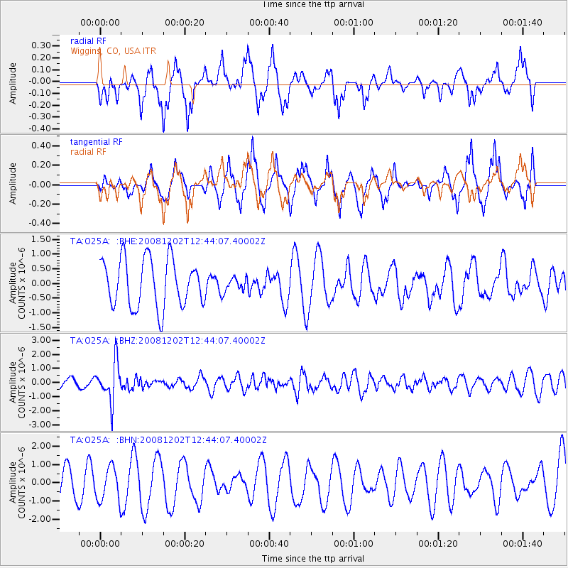
O25A Wiggins, CO, USA - Earthquake Result Viewer
*The percent match for this event was below the threshold and hence no stack was calculated.
| Earthquake location: |
Mariana Islands |
| Earthquake latitude/longitude: |
19.1/145.8 |
| Earthquake time(UTC): |
2008/12/02 (337) 12:31:43 GMT |
| Earthquake Depth: |
137 km |
| Earthquake Magnitude: |
5.9 MB, 5.9 MW, 5.9 MW |
| Earthquake Catalog/Contributor: |
WHDF/NEIC |
|
| Network: |
TA USArray Transportable Network (new EarthScope stations) |
| Station: |
O25A Wiggins, CO, USA |
| Lat/Lon: |
40.11 N/104.12 W |
| Elevation: |
1444 m |
|
| Distance: |
92.3 deg |
| Az: |
46.109 deg |
| Baz: |
297.308 deg |
| Ray Param: |
$rayparam |
*The percent match for this event was below the threshold and hence was not used in the summary stack. |
|
| Radial Match: |
63.674828 % |
| Radial Bump: |
376 |
| Transverse Match: |
49.98757 % |
| Transverse Bump: |
322 |
| SOD ConfigId: |
2658 |
| Insert Time: |
2010-03-06 21:09:41.687 +0000 |
| GWidth: |
2.5 |
| Max Bumps: |
400 |
| Tol: |
0.001 |
|
Signal To Noise
| Channel | StoN | STA | LTA |
| TA:O25A: :BHZ:20081202T12:44:07.40002Z | 3.9393568 | 1.408434E-6 | 3.575289E-7 |
| TA:O25A: :BHN:20081202T12:44:07.40002Z | 1.1043532 | 9.493583E-7 | 8.59651E-7 |
| TA:O25A: :BHE:20081202T12:44:07.40002Z | 0.2795903 | 2.285422E-7 | 8.1741814E-7 |
| Arrivals |
| Ps | |
| PpPs | |
| PsPs/PpSs | |


