You are here: Home > Network List > TS - TERRAscope (Southern California Seismic Network) Stations List
> Station DGR Domenigoni Valley Reservior, California, USA > Earthquake Result Viewer
DGR Domenigoni Valley Reservior, California, USA - Earthquake Result Viewer

| Earthquake location: |
South Of Kermadec Islands |
| Earthquake latitude/longitude: |
-32.1/179.8 |
| Earthquake time(UTC): |
1997/05/25 (145) 23:22:33 GMT |
| Earthquake Depth: |
333 km |
| Earthquake Magnitude: |
6.2 MB, 7.1 UNKNOWN, 7.0 MW |
| Earthquake Catalog/Contributor: |
WHDF/NEIC |
|
| Network: |
TS TERRAscope (Southern California Seismic Network) |
| Station: |
DGR Domenigoni Valley Reservior, California, USA |
| Lat/Lon: |
33.65 N/117.01 W |
| Elevation: |
700 m |
|
| Distance: |
88.4 deg |
| Az: |
48.144 deg |
| Baz: |
229.263 deg |
| Ray Param: |
0.041770138 |
| Estimated Moho Depth: |
32.75 km |
| Estimated Crust Vp/Vs: |
1.79 |
| Assumed Crust Vp: |
6.264 km/s |
| Estimated Crust Vs: |
3.509 km/s |
| Estimated Crust Poisson's Ratio: |
0.27 |
|
| Radial Match: |
94.81674 % |
| Radial Bump: |
303 |
| Transverse Match: |
89.63794 % |
| Transverse Bump: |
400 |
| SOD ConfigId: |
6273 |
| Insert Time: |
2010-02-26 14:09:38.244 +0000 |
| GWidth: |
2.5 |
| Max Bumps: |
400 |
| Tol: |
0.001 |
|
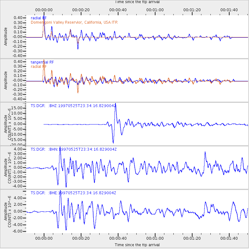
Signal To Noise
| Channel | StoN | STA | LTA |
| TS:DGR: :BHN:19970525T23:34:16.829004Z | 2.0247838 | 1.9363823E-7 | 9.563403E-8 |
| TS:DGR: :BHE:19970525T23:34:16.829004Z | 1.7706634 | 1.6273988E-7 | 9.190899E-8 |
| TS:DGR: :BHZ:19970525T23:34:16.829004Z | 8.173476 | 7.331423E-7 | 8.9697735E-8 |
| Arrivals |
| Ps | 4.2 SECOND |
| PpPs | 14 SECOND |
| PsPs/PpSs | 18 SECOND |


