You are here: Home > Network List > TA - USArray Transportable Network (new EarthScope stations) Stations List
> Station O25A Wiggins, CO, USA > Earthquake Result Viewer
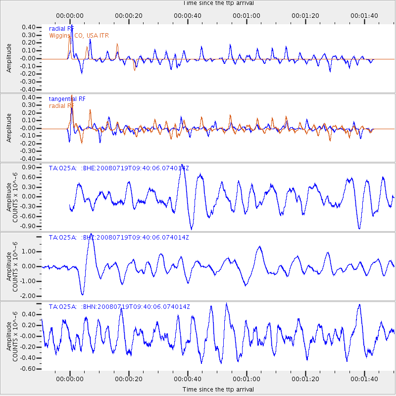
O25A Wiggins, CO, USA - Earthquake Result Viewer
*The percent match for this event was below the threshold and hence no stack was calculated.
| Earthquake location: |
Santa Cruz Islands Region |
| Earthquake latitude/longitude: |
-11.0/164.5 |
| Earthquake time(UTC): |
2008/07/19 (201) 09:27:01 GMT |
| Earthquake Depth: |
11 km |
| Earthquake Magnitude: |
6.1 MB, 6.4 MS, 6.6 MW, 6.6 MW |
| Earthquake Catalog/Contributor: |
WHDF/NEIC |
|
| Network: |
TA USArray Transportable Network (new EarthScope stations) |
| Station: |
O25A Wiggins, CO, USA |
| Lat/Lon: |
40.11 N/104.12 W |
| Elevation: |
1444 m |
|
| Distance: |
98.1 deg |
| Az: |
50.745 deg |
| Baz: |
262.416 deg |
| Ray Param: |
$rayparam |
*The percent match for this event was below the threshold and hence was not used in the summary stack. |
|
| Radial Match: |
84.01354 % |
| Radial Bump: |
388 |
| Transverse Match: |
70.921524 % |
| Transverse Bump: |
400 |
| SOD ConfigId: |
2504 |
| Insert Time: |
2010-03-06 21:10:00.325 +0000 |
| GWidth: |
2.5 |
| Max Bumps: |
400 |
| Tol: |
0.001 |
|
Signal To Noise
| Channel | StoN | STA | LTA |
| TA:O25A: :BHZ:20080719T09:40:06.074014Z | 9.424063 | 8.448146E-7 | 8.9644416E-8 |
| TA:O25A: :BHN:20080719T09:40:06.074014Z | 0.76397055 | 1.4596576E-7 | 1.9106201E-7 |
| TA:O25A: :BHE:20080719T09:40:06.074014Z | 0.65141857 | 1.4255431E-7 | 2.1883672E-7 |
| Arrivals |
| Ps | |
| PpPs | |
| PsPs/PpSs | |


