You are here: Home > Network List > OH - Ohio Seismic Network Stations List
> Station SSFO Shawnee State Forest Ohio > Earthquake Result Viewer
SSFO Shawnee State Forest Ohio - Earthquake Result Viewer
| Earthquake location: |
Near Coast Of Ecuador |
| Earthquake latitude/longitude: |
-2.0/-80.8 |
| Earthquake time(UTC): |
2019/03/31 (090) 07:04:04 GMT |
| Earthquake Depth: |
19 km |
| Earthquake Magnitude: |
6.2 Mww |
| Earthquake Catalog/Contributor: |
NEIC PDE/us |
|
| Network: |
OH Ohio Seismic Network |
| Station: |
SSFO Shawnee State Forest Ohio |
| Lat/Lon: |
38.70 N/83.20 W |
| Elevation: |
365 m |
|
| Distance: |
40.5 deg |
| Az: |
357.123 deg |
| Baz: |
176.325 deg |
| Ray Param: |
0.074320525 |
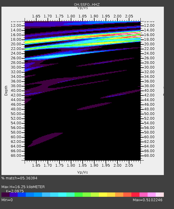
| Estimated Moho Depth: |
16.25 km |
| Estimated Crust Vp/Vs: |
2.10 |
| Assumed Crust Vp: |
6.232 km/s |
| Estimated Crust Vs: |
2.971 km/s |
| Estimated Crust Poisson's Ratio: |
0.35 |
|
| Radial Match: |
85.36394 % |
| Radial Bump: |
299 |
| Transverse Match: |
51.79647 % |
| Transverse Bump: |
400 |
| SOD ConfigId: |
13570011 |
| Insert Time: |
2019-05-02 20:30:35.975 +0000 |
| GWidth: |
2.5 |
| Max Bumps: |
400 |
| Tol: |
0.001 |
|

Signal To Noise
| Channel | StoN | STA | LTA |
| OH:SSFO: :HHZ:20190331T07:11:11.729988Z | 3.1742015 | 1.2668146E-6 | 3.990971E-7 |
| OH:SSFO: :HHN:20190331T07:11:11.729988Z | 1.4098805 | 1.0665838E-6 | 7.565065E-7 |
| OH:SSFO: :HHE:20190331T07:11:11.729988Z | 1.0545659 | 3.116642E-7 | 2.955379E-7 |
| Arrivals |
| Ps | 3.0 SECOND |
| PpPs | 7.6 SECOND |
| PsPs/PpSs | 11 SECOND |


