You are here: Home > Network List > ON - RSIS-Rede Sismografica do Sul e Sudeste Observatorio Nacional, Brazil Stations List
> Station GUA01 "OBSN: [GUA01] Guaratinga, BA" > Earthquake Result Viewer
GUA01 "OBSN: [GUA01] Guaratinga, BA" - Earthquake Result Viewer
| Earthquake location: |
Near Coast Of Ecuador |
| Earthquake latitude/longitude: |
-2.0/-80.8 |
| Earthquake time(UTC): |
2019/03/31 (090) 07:04:04 GMT |
| Earthquake Depth: |
19 km |
| Earthquake Magnitude: |
6.2 Mww |
| Earthquake Catalog/Contributor: |
NEIC PDE/us |
|
| Network: |
ON RSIS-Rede Sismografica do Sul e Sudeste Observatorio Nacional, Brazil |
| Station: |
GUA01 "OBSN: [GUA01] Guaratinga, BA" |
| Lat/Lon: |
16.58 S/39.81 W |
| Elevation: |
198 m |
|
| Distance: |
42.9 deg |
| Az: |
112.343 deg |
| Baz: |
285.426 deg |
| Ray Param: |
0.0728975 |
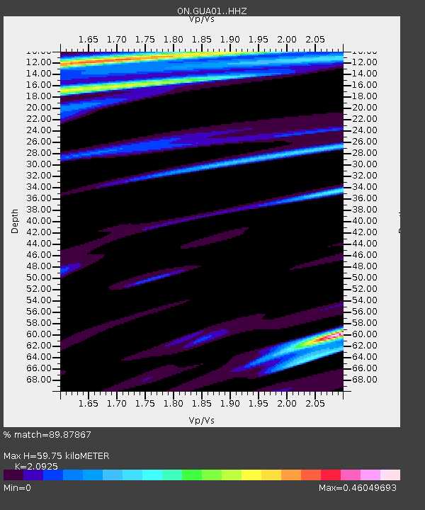
| Estimated Moho Depth: |
59.75 km |
| Estimated Crust Vp/Vs: |
2.09 |
| Assumed Crust Vp: |
6.391 km/s |
| Estimated Crust Vs: |
3.054 km/s |
| Estimated Crust Poisson's Ratio: |
0.35 |
|
| Radial Match: |
89.87867 % |
| Radial Bump: |
400 |
| Transverse Match: |
63.760674 % |
| Transverse Bump: |
400 |
| SOD ConfigId: |
13570011 |
| Insert Time: |
2019-05-02 20:30:46.851 +0000 |
| GWidth: |
2.5 |
| Max Bumps: |
400 |
| Tol: |
0.001 |
|

Signal To Noise
| Channel | StoN | STA | LTA |
| ON:GUA01: :HHZ:20190331T07:11:31.168007Z | 7.178644 | 1.5149951E-6 | 2.1104195E-7 |
| ON:GUA01: :HHN:20190331T07:11:31.168007Z | 1.3129333 | 2.3856578E-7 | 1.8170441E-7 |
| ON:GUA01: :HHE:20190331T07:11:31.168007Z | 4.385231 | 7.4892705E-7 | 1.7078393E-7 |
| Arrivals |
| Ps | 11 SECOND |
| PpPs | 27 SECOND |
| PsPs/PpSs | 38 SECOND |


