You are here: Home > Network List > TA - USArray Transportable Network (new EarthScope stations) Stations List
> Station A21K Barrow, AK, USA > Earthquake Result Viewer
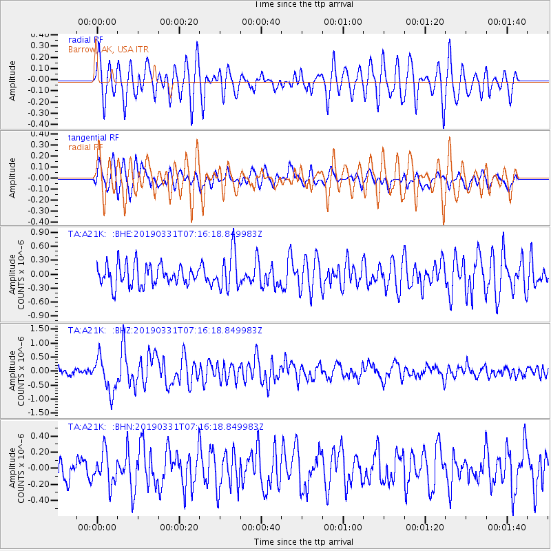
A21K Barrow, AK, USA - Earthquake Result Viewer
*The percent match for this event was below the threshold and hence no stack was calculated.
| Earthquake location: |
Near Coast Of Ecuador |
| Earthquake latitude/longitude: |
-2.0/-80.8 |
| Earthquake time(UTC): |
2019/03/31 (090) 07:04:04 GMT |
| Earthquake Depth: |
19 km |
| Earthquake Magnitude: |
6.2 Mww |
| Earthquake Catalog/Contributor: |
NEIC PDE/us |
|
| Network: |
TA USArray Transportable Network (new EarthScope stations) |
| Station: |
A21K Barrow, AK, USA |
| Lat/Lon: |
71.32 N/156.62 W |
| Elevation: |
577 m |
|
| Distance: |
87.3 deg |
| Az: |
341.779 deg |
| Baz: |
104.081 deg |
| Ray Param: |
$rayparam |
*The percent match for this event was below the threshold and hence was not used in the summary stack. |
|
| Radial Match: |
61.740513 % |
| Radial Bump: |
400 |
| Transverse Match: |
71.738716 % |
| Transverse Bump: |
400 |
| SOD ConfigId: |
13570011 |
| Insert Time: |
2019-05-02 20:32:32.964 +0000 |
| GWidth: |
2.5 |
| Max Bumps: |
400 |
| Tol: |
0.001 |
|
Signal To Noise
| Channel | StoN | STA | LTA |
| TA:A21K: :BHZ:20190331T07:16:18.849983Z | 4.686321 | 6.391163E-7 | 1.3637913E-7 |
| TA:A21K: :BHN:20190331T07:16:18.849983Z | 1.2131374 | 1.9846152E-7 | 1.6359361E-7 |
| TA:A21K: :BHE:20190331T07:16:18.849983Z | 1.8861728 | 4.196188E-7 | 2.2247104E-7 |
| Arrivals |
| Ps | |
| PpPs | |
| PsPs/PpSs | |


