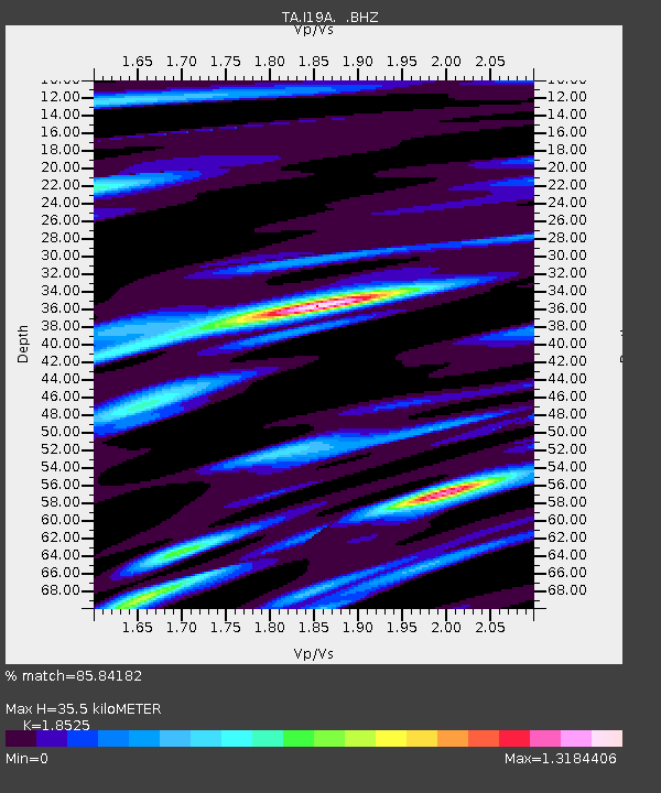
I19A Meeteetse, WY, USA - Earthquake Result Viewer
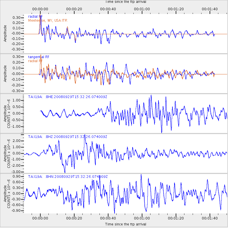
Earthquake location: Kermadec Islands, New Zealand
Earthquake latitude/longitude: -29.8/-177.7
Earthquake time(UTC): 2008/09/29 (273) 15:19:31 GMT
Earthquake Depth: 36 km
Earthquake Magnitude: 6.5 MB, 6.7 MS, 7.0 MW, 7.0 MW
Earthquake Catalog/Contributor: WHDF/NEIC
Network: TA USArray Transportable Network (new EarthScope stations)
Station: I19A Meeteetse, WY, USA
Lat/Lon: 44.04 N/108.99 W
Elevation: 1982 m
Distance: 96.6 deg
Az: 42.557 deg
Baz: 234.631 deg
Ray Param: 0.040462498
Estimated Moho Depth: 35.5 km
Estimated Crust Vp/Vs: 1.85
Assumed Crust Vp: 6.242 km/s
Estimated Crust Vs: 3.37 km/s
Estimated Crust Poisson's Ratio: 0.29
Radial Match: 85.84182 %
Radial Bump: 400
Transverse Match: 82.59889 %
Transverse Bump: 400
SOD ConfigId: 2560
Insert Time: 2010-03-06 21:10:28.499 +0000
GWidth: 2.5
Max Bumps: 400
Tol: 0.001

Signal To Noise

ChannelStoNSTALTA
TA:I19A: :BHZ:20080929T15:32:26.074009Z4.3861023.8142858E-78.6963E-8
TA:I19A: :BHN:20080929T15:32:26.074009Z0.88619381.4708763E-71.6597681E-7
TA:I19A: :BHE:20080929T15:32:26.074009Z1.09087791.6891408E-71.5484234E-7
Arrivals
Ps4.9 SECOND
PpPs16 SECOND
PsPs/PpSs21 SECOND