You are here: Home > Network List > TA - USArray Transportable Network (new EarthScope stations) Stations List
> Station I19A Meeteetse, WY, USA > Earthquake Result Viewer
I19A Meeteetse, WY, USA - Earthquake Result Viewer
| Earthquake location: |
East Of Kuril Islands |
| Earthquake latitude/longitude: |
46.9/155.2 |
| Earthquake time(UTC): |
2009/01/15 (015) 17:49:39 GMT |
| Earthquake Depth: |
36 km |
| Earthquake Magnitude: |
6.9 MB, 7.5 MS, 7.4 MW, 7.4 MW |
| Earthquake Catalog/Contributor: |
WHDF/NEIC |
|
| Network: |
TA USArray Transportable Network (new EarthScope stations) |
| Station: |
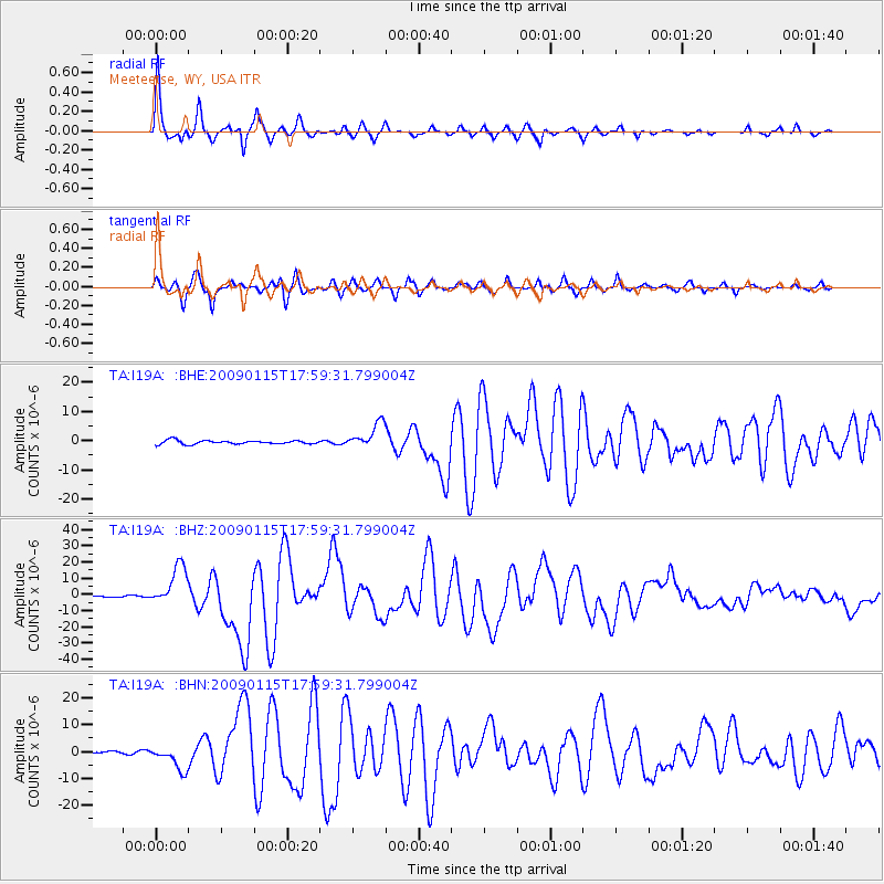
I19A Meeteetse, WY, USA |
| Lat/Lon: |
44.04 N/108.99 W |
| Elevation: |
1982 m |
|
| Distance: |
63.0 deg |
| Az: |
53.606 deg |
| Baz: |
310.01 deg |
| Ray Param: |
0.05977287 |
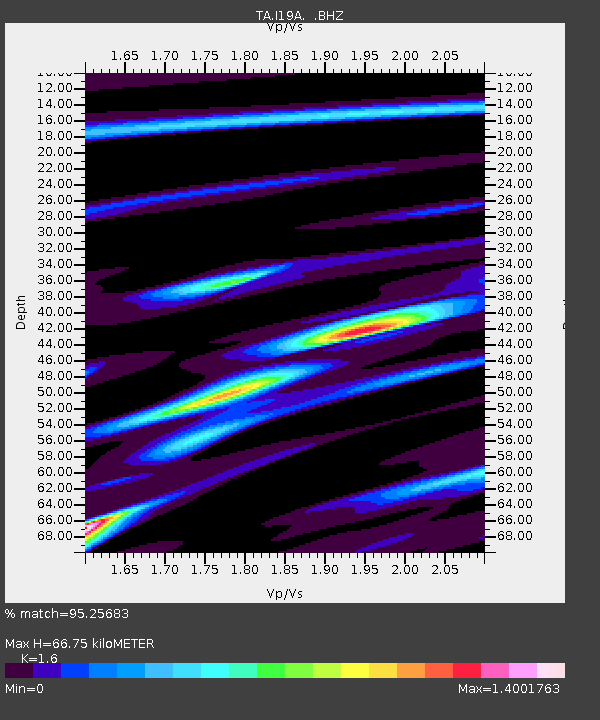
| Estimated Moho Depth: |
66.75 km |
| Estimated Crust Vp/Vs: |
1.60 |
| Assumed Crust Vp: |
6.242 km/s |
| Estimated Crust Vs: |
3.901 km/s |
| Estimated Crust Poisson's Ratio: |
0.18 |
|
| Radial Match: |
95.25683 % |
| Radial Bump: |
365 |
| Transverse Match: |
93.204475 % |
| Transverse Bump: |
400 |
| SOD ConfigId: |
2834 |
| Insert Time: |
2010-03-06 21:10:29.831 +0000 |
| GWidth: |
2.5 |
| Max Bumps: |
400 |
| Tol: |
0.001 |
|
Signal To Noise
| Channel | StoN | STA | LTA |
| TA:I19A: :BHZ:20090115T17:59:31.799004Z | 25.882568 | 1.2436295E-5 | 4.804892E-7 |
| TA:I19A: :BHN:20090115T17:59:31.799004Z | 10.851769 | 4.585792E-6 | 4.2258472E-7 |
| TA:I19A: :BHE:20090115T17:59:31.799004Z | 6.839984 | 4.317739E-6 | 6.3124986E-7 |
| Arrivals |
| Ps | 6.7 SECOND |
| PpPs | 27 SECOND |
| PsPs/PpSs | 33 SECOND |


