You are here: Home > Network List > TA - USArray Transportable Network (new EarthScope stations) Stations List
> Station I19A Meeteetse, WY, USA > Earthquake Result Viewer
I19A Meeteetse, WY, USA - Earthquake Result Viewer
| Earthquake location: |
Off Coast Of Costa Rica |
| Earthquake latitude/longitude: |
7.9/-85.6 |
| Earthquake time(UTC): |
2009/08/13 (225) 09:37:35 GMT |
| Earthquake Depth: |
10 km |
| Earthquake Magnitude: |
5.8 MW, 5.3 MB |
| Earthquake Catalog/Contributor: |
WHDF/NEIC |
|
| Network: |
TA USArray Transportable Network (new EarthScope stations) |
| Station: |
I19A Meeteetse, WY, USA |
| Lat/Lon: |
44.04 N/108.99 W |
| Elevation: |
1982 m |
|
| Distance: |
41.3 deg |
| Az: |
334.335 deg |
| Baz: |
143.501 deg |
| Ray Param: |
0.07386337 |
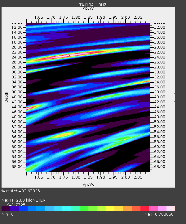
| Estimated Moho Depth: |
23.0 km |
| Estimated Crust Vp/Vs: |
1.77 |
| Assumed Crust Vp: |
6.242 km/s |
| Estimated Crust Vs: |
3.522 km/s |
| Estimated Crust Poisson's Ratio: |
0.27 |
|
| Radial Match: |
83.67325 % |
| Radial Bump: |
400 |
| Transverse Match: |
73.87855 % |
| Transverse Bump: |
400 |
| SOD ConfigId: |
2622 |
| Insert Time: |
2010-03-06 21:10:39.470 +0000 |
| GWidth: |
2.5 |
| Max Bumps: |
400 |
| Tol: |
0.001 |
|
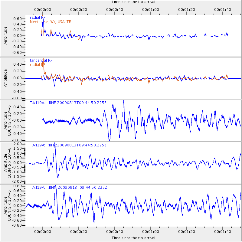
Signal To Noise
| Channel | StoN | STA | LTA |
| TA:I19A: :BHZ:20090813T09:44:50.225Z | 8.669967 | 4.0592252E-7 | 4.6819387E-8 |
| TA:I19A: :BHN:20090813T09:44:50.225Z | 1.6106942 | 8.9991744E-8 | 5.5871404E-8 |
| TA:I19A: :BHE:20090813T09:44:50.225Z | 3.2120986 | 1.3646142E-7 | 4.2483574E-8 |
| Arrivals |
| Ps | 3.0 SECOND |
| PpPs | 9.6 SECOND |
| PsPs/PpSs | 13 SECOND |


