You are here: Home > Network List > TA - USArray Transportable Network (new EarthScope stations) Stations List
> Station I19A Meeteetse, WY, USA > Earthquake Result Viewer
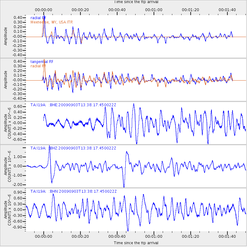
I19A Meeteetse, WY, USA - Earthquake Result Viewer
| Earthquake location: |
Kyushu, Japan |
| Earthquake latitude/longitude: |
31.1/130.0 |
| Earthquake time(UTC): |
2009/09/03 (246) 13:26:18 GMT |
| Earthquake Depth: |
166 km |
| Earthquake Magnitude: |
5.9 MB, 6.2 MW, 6.2 MW |
| Earthquake Catalog/Contributor: |
WHDF/NEIC |
|
| Network: |
TA USArray Transportable Network (new EarthScope stations) |
| Station: |
I19A Meeteetse, WY, USA |
| Lat/Lon: |
44.04 N/108.99 W |
| Elevation: |
1982 m |
|
| Distance: |
87.8 deg |
| Az: |
38.227 deg |
| Baz: |
312.64 deg |
| Ray Param: |
0.04267316 |
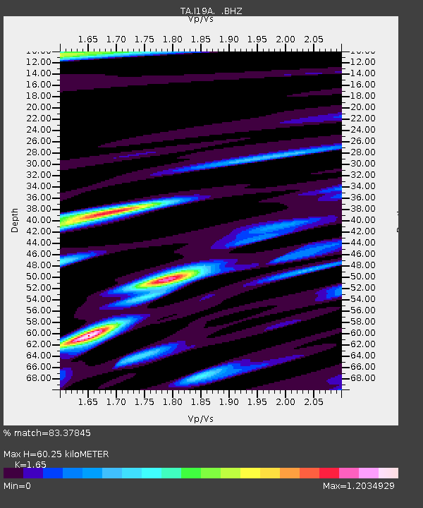
| Estimated Moho Depth: |
60.25 km |
| Estimated Crust Vp/Vs: |
1.65 |
| Assumed Crust Vp: |
6.242 km/s |
| Estimated Crust Vs: |
3.783 km/s |
| Estimated Crust Poisson's Ratio: |
0.21 |
|
| Radial Match: |
83.37845 % |
| Radial Bump: |
400 |
| Transverse Match: |
77.80816 % |
| Transverse Bump: |
400 |
| SOD ConfigId: |
2622 |
| Insert Time: |
2010-03-06 21:10:48.063 +0000 |
| GWidth: |
2.5 |
| Max Bumps: |
400 |
| Tol: |
0.001 |
|
Signal To Noise
| Channel | StoN | STA | LTA |
| TA:I19A: :BHZ:20090903T13:38:17.450022Z | 9.6213045 | 9.514197E-7 | 9.888677E-8 |
| TA:I19A: :BHN:20090903T13:38:17.450022Z | 2.2045338 | 2.85528E-7 | 1.2951854E-7 |
| TA:I19A: :BHE:20090903T13:38:17.450022Z | 2.5734668 | 2.4446044E-7 | 9.499264E-8 |
| Arrivals |
| Ps | 6.4 SECOND |
| PpPs | 25 SECOND |
| PsPs/PpSs | 31 SECOND |


