You are here: Home > Network List > TA - USArray Transportable Network (new EarthScope stations) Stations List
> Station I19A Meeteetse, WY, USA > Earthquake Result Viewer
I19A Meeteetse, WY, USA - Earthquake Result Viewer

| Earthquake location: |
Santa Cruz Islands |
| Earthquake latitude/longitude: |
-12.4/166.1 |
| Earthquake time(UTC): |
2009/10/07 (280) 22:50:15 GMT |
| Earthquake Depth: |
21 km |
| Earthquake Magnitude: |
5.8 MB |
| Earthquake Catalog/Contributor: |
WHDF/NEIC |
|
| Network: |
TA USArray Transportable Network (new EarthScope stations) |
| Station: |
I19A Meeteetse, WY, USA |
| Lat/Lon: |
44.04 N/108.99 W |
| Elevation: |
1982 m |
|
| Distance: |
94.9 deg |
| Az: |
46.139 deg |
| Baz: |
257.615 deg |
| Ray Param: |
0.04092076 |
| Estimated Moho Depth: |
10.0 km |
| Estimated Crust Vp/Vs: |
1.60 |
| Assumed Crust Vp: |
6.242 km/s |
| Estimated Crust Vs: |
3.901 km/s |
| Estimated Crust Poisson's Ratio: |
0.18 |
|
| Radial Match: |
95.56039 % |
| Radial Bump: |
358 |
| Transverse Match: |
68.620544 % |
| Transverse Bump: |
250 |
| SOD ConfigId: |
2622 |
| Insert Time: |
2010-03-06 21:10:56.715 +0000 |
| GWidth: |
2.5 |
| Max Bumps: |
400 |
| Tol: |
0.001 |
|
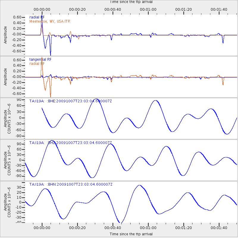
Signal To Noise
| Channel | StoN | STA | LTA |
| TA:I19A: :BHZ:20091007T23:03:04.600007Z | 1.4326507 | 6.71542E-5 | 4.6874095E-5 |
| TA:I19A: :BHN:20091007T23:03:04.600007Z | 1.8844458 | 2.8663771E-5 | 1.5210717E-5 |
| TA:I19A: :BHE:20091007T23:03:04.600007Z | 3.53153 | 9.407979E-5 | 2.6639953E-5 |
| Arrivals |
| Ps | 1.0 SECOND |
| PpPs | 4.1 SECOND |
| PsPs/PpSs | 5.1 SECOND |


