I19A Meeteetse, WY, USA - Earthquake Result Viewer
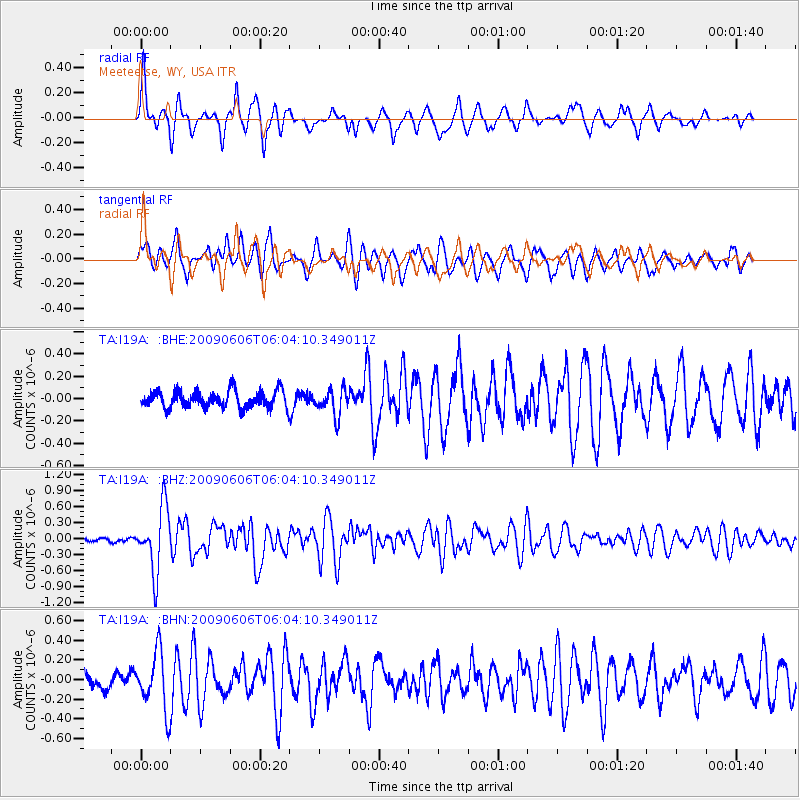
Earthquake location: Near East Coast Of Honshu, Japan
Earthquake latitude/longitude: 35.5/140.9
Earthquake time(UTC): 2009/06/06 (157) 05:52:43 GMT
Earthquake Depth: 34 km
Earthquake Magnitude: 5.8 MB, 5.4 MS, 5.8 MW, 5.7 MW
Earthquake Catalog/Contributor: WHDF/NEIC
Network: TA USArray Transportable Network (new EarthScope stations)
Station: I19A Meeteetse, WY, USA
Lat/Lon: 44.04 N/108.99 W
Elevation: 1982 m
Distance: 78.6 deg
Az: 43.712 deg
Baz: 308.56 deg
Ray Param: 0.049500793
Estimated Moho Depth: 38.5 km
Estimated Crust Vp/Vs: 1.72
Assumed Crust Vp: 6.242 km/s
Estimated Crust Vs: 3.64 km/s
Estimated Crust Poisson's Ratio: 0.24
Radial Match: 86.94171 %
Radial Bump: 351
Transverse Match: 75.549774 %
Transverse Bump: 400
SOD ConfigId: 2648
Insert Time: 2010-03-06 21:11:05.669 +0000
GWidth: 2.5
Max Bumps: 400
Tol: 0.001

Signal To Noise

ChannelStoNSTALTA
TA:I19A: :BHZ:20090606T06:04:10.349011Z11.6995115.9649255E-75.09844E-8
TA:I19A: :BHN:20090606T06:04:10.349011Z4.4072312.937012E-76.664076E-8
TA:I19A: :BHE:20090606T06:04:10.349011Z1.57624891.172394E-77.437874E-8
Arrivals
Ps4.5 SECOND
PpPs16 SECOND
PsPs/PpSs21 SECOND