You are here: Home > Network List > TA - USArray Transportable Network (new EarthScope stations) Stations List
> Station I19A Meeteetse, WY, USA > Earthquake Result Viewer
I19A Meeteetse, WY, USA - Earthquake Result Viewer
| Earthquake location: |
Tonga Islands Region |
| Earthquake latitude/longitude: |
-23.0/-174.7 |
| Earthquake time(UTC): |
2009/03/19 (078) 18:17:40 GMT |
| Earthquake Depth: |
34 km |
| Earthquake Magnitude: |
7.0 MB, 7.6 MS, 7.6 MW, 7.6 MW |
| Earthquake Catalog/Contributor: |
WHDF/NEIC |
|
| Network: |
TA USArray Transportable Network (new EarthScope stations) |
| Station: |
I19A Meeteetse, WY, USA |
| Lat/Lon: |
44.04 N/108.99 W |
| Elevation: |
1982 m |
|
| Distance: |
89.8 deg |
| Az: |
41.083 deg |
| Baz: |
237.066 deg |
| Ray Param: |
0.041717336 |
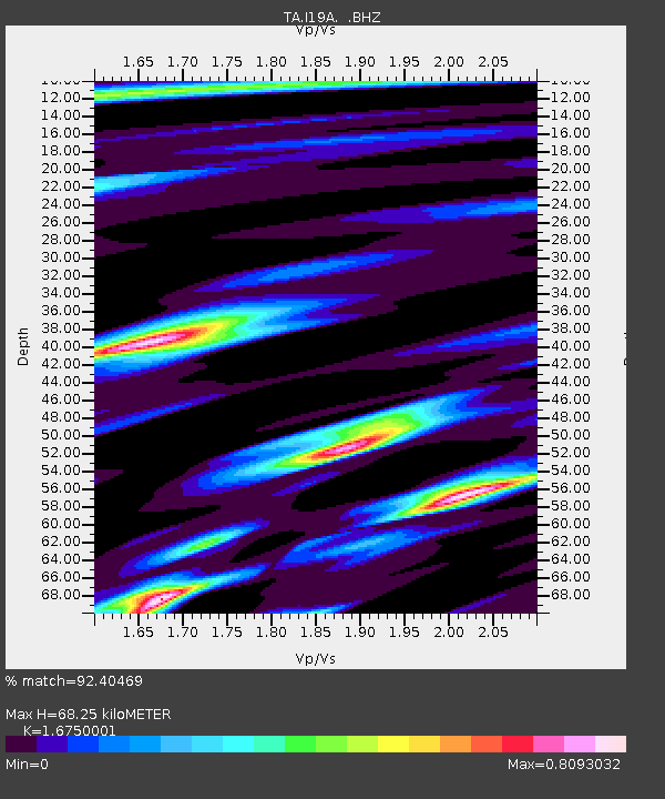
| Estimated Moho Depth: |
68.25 km |
| Estimated Crust Vp/Vs: |
1.68 |
| Assumed Crust Vp: |
6.242 km/s |
| Estimated Crust Vs: |
3.727 km/s |
| Estimated Crust Poisson's Ratio: |
0.22 |
|
| Radial Match: |
92.40469 % |
| Radial Bump: |
400 |
| Transverse Match: |
83.92451 % |
| Transverse Bump: |
400 |
| SOD ConfigId: |
2658 |
| Insert Time: |
2010-03-06 21:11:18.759 +0000 |
| GWidth: |
2.5 |
| Max Bumps: |
400 |
| Tol: |
0.001 |
|
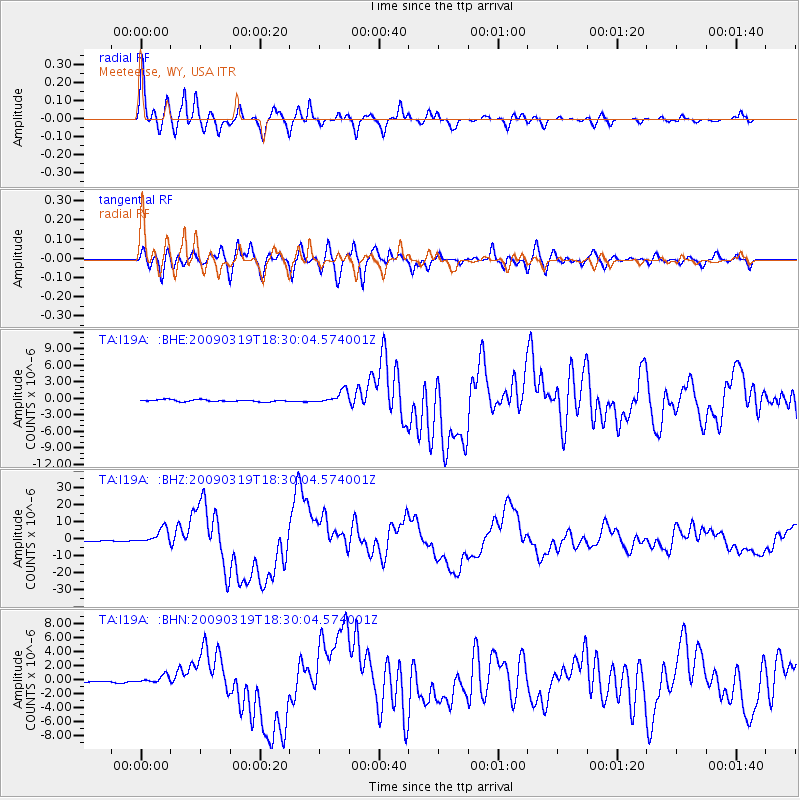
Signal To Noise
| Channel | StoN | STA | LTA |
| TA:I19A: :BHZ:20090319T18:30:04.574001Z | 18.197939 | 4.407663E-6 | 2.422067E-7 |
| TA:I19A: :BHN:20090319T18:30:04.574001Z | 4.468997 | 5.7730523E-7 | 1.2918004E-7 |
| TA:I19A: :BHE:20090319T18:30:04.574001Z | 6.8064156 | 1.1735608E-6 | 1.724198E-7 |
| Arrivals |
| Ps | 7.5 SECOND |
| PpPs | 29 SECOND |
| PsPs/PpSs | 36 SECOND |


