You are here: Home > Network List > TD - TransAlta Monitoring Network Stations List
> Station TD010 Z > Earthquake Result Viewer
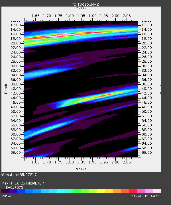
TD010 Z - Earthquake Result Viewer
| Earthquake location: |
Near Coast Of Ecuador |
| Earthquake latitude/longitude: |
-2.0/-80.8 |
| Earthquake time(UTC): |
2019/03/31 (090) 07:04:04 GMT |
| Earthquake Depth: |
19 km |
| Earthquake Magnitude: |
6.2 Mww |
| Earthquake Catalog/Contributor: |
NEIC PDE/us |
|
| Network: |
TD TransAlta Monitoring Network |
| Station: |
TD010 Z |
| Lat/Lon: |
52.64 N/116.33 W |
| Elevation: |
1637 m |
|
| Distance: |
62.1 deg |
| Az: |
336.373 deg |
| Baz: |
138.908 deg |
| Ray Param: |
0.060450967 |
| Estimated Moho Depth: |
16.25 km |
| Estimated Crust Vp/Vs: |
1.77 |
| Assumed Crust Vp: |
6.142 km/s |
| Estimated Crust Vs: |
3.475 km/s |
| Estimated Crust Poisson's Ratio: |
0.26 |
|
| Radial Match: |
85.07817 % |
| Radial Bump: |
336 |
| Transverse Match: |
74.304726 % |
| Transverse Bump: |
400 |
| SOD ConfigId: |
13570011 |
| Insert Time: |
2019-05-02 20:34:20.739 +0000 |
| GWidth: |
2.5 |
| Max Bumps: |
400 |
| Tol: |
0.001 |
|

Signal To Noise
| Channel | StoN | STA | LTA |
| TD:TD010: :HHZ:20190331T07:13:52.90998Z | 2.582852 | 5.527041E-7 | 2.1398985E-7 |
| TD:TD010: :HH1:20190331T07:13:52.90998Z | 1.7200643 | 1.8867401E-7 | 1.0969009E-7 |
| TD:TD010: :HH2:20190331T07:13:52.90998Z | 1.0314631 | 1.7049555E-7 | 1.6529486E-7 |
| Arrivals |
| Ps | 2.1 SECOND |
| PpPs | 7.0 SECOND |
| PsPs/PpSs | 9.1 SECOND |


