You are here: Home > Network List > TD - TransAlta Monitoring Network Stations List
> Station TD13A Z > Earthquake Result Viewer
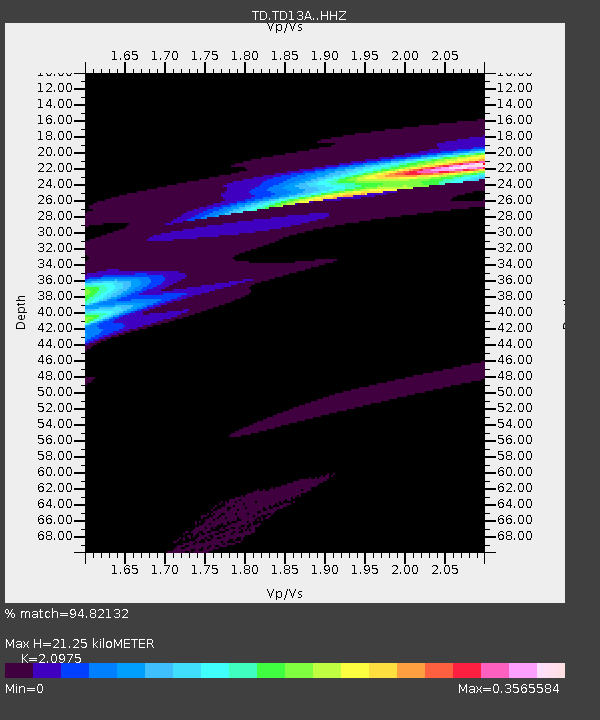
TD13A Z - Earthquake Result Viewer
| Earthquake location: |
Near Coast Of Ecuador |
| Earthquake latitude/longitude: |
-2.0/-80.8 |
| Earthquake time(UTC): |
2019/03/31 (090) 07:04:04 GMT |
| Earthquake Depth: |
19 km |
| Earthquake Magnitude: |
6.2 Mww |
| Earthquake Catalog/Contributor: |
NEIC PDE/us |
|
| Network: |
TD TransAlta Monitoring Network |
| Station: |
TD13A Z |
| Lat/Lon: |
52.01 N/114.77 W |
| Elevation: |
1182 m |
|
| Distance: |
61.0 deg |
| Az: |
336.739 deg |
| Baz: |
140.318 deg |
| Ray Param: |
0.061163917 |
| Estimated Moho Depth: |
21.25 km |
| Estimated Crust Vp/Vs: |
2.10 |
| Assumed Crust Vp: |
6.426 km/s |
| Estimated Crust Vs: |
3.064 km/s |
| Estimated Crust Poisson's Ratio: |
0.35 |
|
| Radial Match: |
94.82132 % |
| Radial Bump: |
130 |
| Transverse Match: |
95.59277 % |
| Transverse Bump: |
101 |
| SOD ConfigId: |
13570011 |
| Insert Time: |
2019-05-02 20:34:23.024 +0000 |
| GWidth: |
2.5 |
| Max Bumps: |
400 |
| Tol: |
0.001 |
|

Signal To Noise
| Channel | StoN | STA | LTA |
| TD:TD13A: :HHZ:20190331T07:13:45.460029Z | 20.470703 | 0.0050450726 | 2.4645333E-4 |
| TD:TD13A: :HH1:20190331T07:13:45.460029Z | 69.18508 | 3.6632406E-4 | 5.294842E-6 |
| TD:TD13A: :HH2:20190331T07:13:45.460029Z | 16.726185 | 0.0019025123 | 1.1374455E-4 |
| Arrivals |
| Ps | 3.8 SECOND |
| PpPs | 9.9 SECOND |
| PsPs/PpSs | 14 SECOND |


