You are here: Home > Network List > UW - Pacific Northwest Regional Seismic Network Stations List
> Station LEBA Lebam, WA, USA > Earthquake Result Viewer
LEBA Lebam, WA, USA - Earthquake Result Viewer

| Earthquake location: |
Near Coast Of Ecuador |
| Earthquake latitude/longitude: |
-2.0/-80.8 |
| Earthquake time(UTC): |
2019/03/31 (090) 07:04:04 GMT |
| Earthquake Depth: |
19 km |
| Earthquake Magnitude: |
6.2 Mww |
| Earthquake Catalog/Contributor: |
NEIC PDE/us |
|
| Network: |
UW Pacific Northwest Regional Seismic Network |
| Station: |
LEBA Lebam, WA, USA |
| Lat/Lon: |
46.55 N/123.56 W |
| Elevation: |
73 m |
|
| Distance: |
61.2 deg |
| Az: |
327.681 deg |
| Baz: |
129.272 deg |
| Ray Param: |
0.06100199 |
| Estimated Moho Depth: |
29.5 km |
| Estimated Crust Vp/Vs: |
1.88 |
| Assumed Crust Vp: |
6.566 km/s |
| Estimated Crust Vs: |
3.488 km/s |
| Estimated Crust Poisson's Ratio: |
0.30 |
|
| Radial Match: |
80.32771 % |
| Radial Bump: |
400 |
| Transverse Match: |
69.19304 % |
| Transverse Bump: |
400 |
| SOD ConfigId: |
13570011 |
| Insert Time: |
2019-05-02 20:35:05.147 +0000 |
| GWidth: |
2.5 |
| Max Bumps: |
400 |
| Tol: |
0.001 |
|
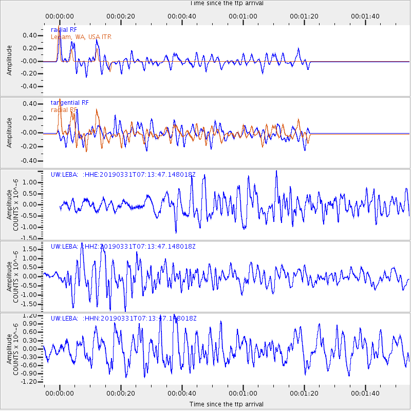
Signal To Noise
| Channel | StoN | STA | LTA |
| UW:LEBA: :HHZ:20190331T07:13:47.148018Z | 2.8594217 | 6.122586E-7 | 2.1411974E-7 |
| UW:LEBA: :HHN:20190331T07:13:47.148018Z | 0.97543406 | 2.5528453E-7 | 2.6171378E-7 |
| UW:LEBA: :HHE:20190331T07:13:47.148018Z | 2.1520987 | 3.5881328E-7 | 1.6672716E-7 |
| Arrivals |
| Ps | 4.1 SECOND |
| PpPs | 12 SECOND |
| PsPs/PpSs | 17 SECOND |


