You are here: Home > Network List > TS - TERRAscope (Southern California Seismic Network) Stations List
> Station DGR Domenigoni Valley Reservior, California, USA > Earthquake Result Viewer
DGR Domenigoni Valley Reservior, California, USA - Earthquake Result Viewer

| Earthquake location: |
Near Coast Of Venezuela |
| Earthquake latitude/longitude: |
10.6/-63.5 |
| Earthquake time(UTC): |
1997/07/09 (190) 19:24:13 GMT |
| Earthquake Depth: |
20 km |
| Earthquake Magnitude: |
6.2 MB, 6.8 MS, 7.0 UNKNOWN, 6.6 ME |
| Earthquake Catalog/Contributor: |
WHDF/NEIC |
|
| Network: |
TS TERRAscope (Southern California Seismic Network) |
| Station: |
DGR Domenigoni Valley Reservior, California, USA |
| Lat/Lon: |
33.65 N/117.01 W |
| Elevation: |
700 m |
|
| Distance: |
54.0 deg |
| Az: |
303.954 deg |
| Baz: |
102.132 deg |
| Ray Param: |
0.06572421 |
| Estimated Moho Depth: |
31.75 km |
| Estimated Crust Vp/Vs: |
1.77 |
| Assumed Crust Vp: |
6.264 km/s |
| Estimated Crust Vs: |
3.534 km/s |
| Estimated Crust Poisson's Ratio: |
0.27 |
|
| Radial Match: |
96.90654 % |
| Radial Bump: |
361 |
| Transverse Match: |
71.4284 % |
| Transverse Bump: |
400 |
| SOD ConfigId: |
6273 |
| Insert Time: |
2010-02-26 14:09:44.792 +0000 |
| GWidth: |
2.5 |
| Max Bumps: |
400 |
| Tol: |
0.001 |
|
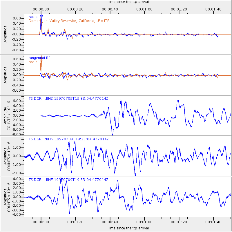
Signal To Noise
| Channel | StoN | STA | LTA |
| TS:DGR: :BHN:19970709T19:33:04.477014Z | 3.030574 | 3.646423E-7 | 1.2032119E-7 |
| TS:DGR: :BHE:19970709T19:33:04.477014Z | 1.7790883 | 3.7751593E-7 | 2.121963E-7 |
| TS:DGR: :BHZ:19970709T19:33:04.477014Z | 2.3646867 | 4.4960615E-7 | 1.9013349E-7 |
| Arrivals |
| Ps | 4.1 SECOND |
| PpPs | 13 SECOND |
| PsPs/PpSs | 17 SECOND |


