You are here: Home > Network List > TA - USArray Transportable Network (new EarthScope stations) Stations List
> Station I19A Meeteetse, WY, USA > Earthquake Result Viewer
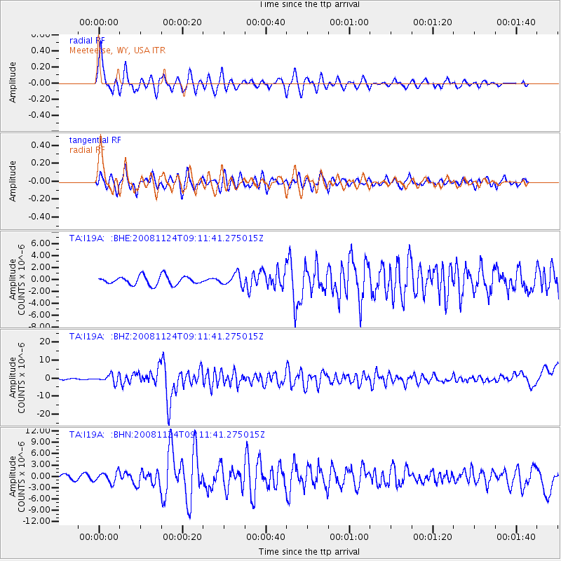
I19A Meeteetse, WY, USA - Earthquake Result Viewer
*The percent match for this event was below the threshold and hence no stack was calculated.
| Earthquake location: |
Sea Of Okhotsk |
| Earthquake latitude/longitude: |
54.2/154.3 |
| Earthquake time(UTC): |
2008/11/24 (329) 09:02:58 GMT |
| Earthquake Depth: |
492 km |
| Earthquake Magnitude: |
6.5 MB, 7.3 MW, 7.3 MW |
| Earthquake Catalog/Contributor: |
WHDF/NEIC |
|
| Network: |
TA USArray Transportable Network (new EarthScope stations) |
| Station: |
I19A Meeteetse, WY, USA |
| Lat/Lon: |
44.04 N/108.99 W |
| Elevation: |
1982 m |
|
| Distance: |
59.3 deg |
| Az: |
56.458 deg |
| Baz: |
317.239 deg |
| Ray Param: |
$rayparam |
*The percent match for this event was below the threshold and hence was not used in the summary stack. |
|
| Radial Match: |
79.686226 % |
| Radial Bump: |
400 |
| Transverse Match: |
72.02687 % |
| Transverse Bump: |
400 |
| SOD ConfigId: |
2658 |
| Insert Time: |
2010-03-06 21:12:10.448 +0000 |
| GWidth: |
2.5 |
| Max Bumps: |
400 |
| Tol: |
0.001 |
|
Signal To Noise
| Channel | StoN | STA | LTA |
| TA:I19A: :BHZ:20081124T09:11:41.275015Z | 7.1640334 | 2.294242E-6 | 3.2024445E-7 |
| TA:I19A: :BHN:20081124T09:11:41.275015Z | 2.4549923 | 1.3880233E-6 | 5.6538806E-7 |
| TA:I19A: :BHE:20081124T09:11:41.275015Z | 1.3973132 | 1.0110911E-6 | 7.235966E-7 |
| Arrivals |
| Ps | |
| PpPs | |
| PsPs/PpSs | |


