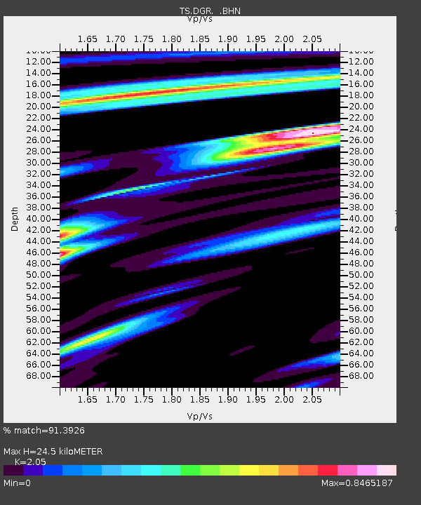
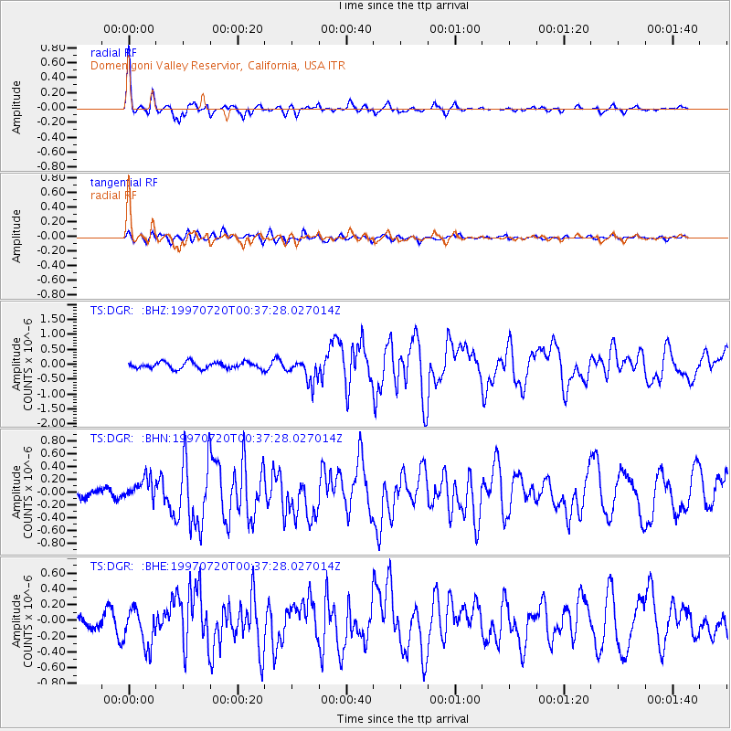
DGR Domenigoni Valley Reservior, California, USA - Earthquake Result Viewer

Earthquake location: Fox Islands, Aleutian Islands
Earthquake latitude/longitude: 52.6/-167.5
Earthquake time(UTC): 1997/07/20 (201) 00:30:20 GMT
Earthquake Depth: 14 km
Earthquake Magnitude: 5.6 MB, 5.9 MS, 6.2 UNKNOWN, 6.2 MW
Earthquake Catalog/Contributor: WHDF/NEIC
Network: TS TERRAscope (Southern California Seismic Network)
Station: DGR Domenigoni Valley Reservior, California, USA
Lat/Lon: 33.65 N/117.01 W
Elevation: 700 m
Distance: 40.5 deg
Az: 97.417 deg
Baz: 313.47 deg
Ray Param: 0.0743825
Estimated Moho Depth: 24.5 km
Estimated Crust Vp/Vs: 2.05
Assumed Crust Vp: 6.264 km/s
Estimated Crust Vs: 3.055 km/s
Estimated Crust Poisson's Ratio: 0.34
Radial Match: 91.3926 %
Radial Bump: 349
Transverse Match: 74.46702 %
Transverse Bump: 400
SOD ConfigId: 6273
Insert Time: 2010-02-26 14:09:47.902 +0000
GWidth: 2.5
Max Bumps: 400
Tol: 0.001

Signal To Noise

ChannelStoNSTALTA
TS:DGR: :BHN:19970720T00:37:28.027014Z2.19580251.8502516E-78.426312E-8
TS:DGR: :BHE:19970720T00:37:28.027014Z3.09988742.457225E-77.92682E-8
TS:DGR: :BHZ:19970720T00:37:28.027014Z3.637684.0102177E-71.10241075E-7
Arrivals
Ps4.3 SECOND
PpPs11 SECOND
PsPs/PpSs16 SECOND