You are here: Home > Network List > TA - USArray Transportable Network (new EarthScope stations) Stations List
> Station E19A Rath Farm, Roundup, MT, USA > Earthquake Result Viewer
E19A Rath Farm, Roundup, MT, USA - Earthquake Result Viewer
| Earthquake location: |
Near Coast Of Chiapas, Mexico |
| Earthquake latitude/longitude: |
14.4/-92.4 |
| Earthquake time(UTC): |
2008/10/16 (290) 19:41:25 GMT |
| Earthquake Depth: |
24 km |
| Earthquake Magnitude: |
6.1 MB, 6.6 MS, 6.7 MW, 6.6 MW |
| Earthquake Catalog/Contributor: |
WHDF/NEIC |
|
| Network: |
TA USArray Transportable Network (new EarthScope stations) |
| Station: |
E19A Rath Farm, Roundup, MT, USA |
| Lat/Lon: |
46.46 N/108.79 W |
| Elevation: |
1059 m |
|
| Distance: |
34.8 deg |
| Az: |
339.967 deg |
| Baz: |
151.307 deg |
| Ray Param: |
0.07752756 |
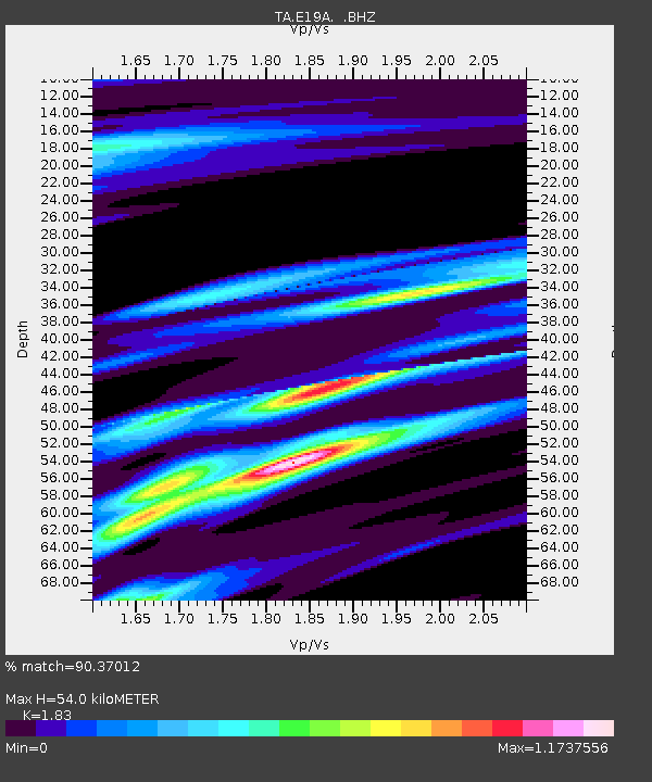
| Estimated Moho Depth: |
54.0 km |
| Estimated Crust Vp/Vs: |
1.83 |
| Assumed Crust Vp: |
6.518 km/s |
| Estimated Crust Vs: |
3.562 km/s |
| Estimated Crust Poisson's Ratio: |
0.29 |
|
| Radial Match: |
90.37012 % |
| Radial Bump: |
307 |
| Transverse Match: |
83.83378 % |
| Transverse Bump: |
400 |
| SOD ConfigId: |
2556 |
| Insert Time: |
2010-03-06 21:13:07.800 +0000 |
| GWidth: |
2.5 |
| Max Bumps: |
400 |
| Tol: |
0.001 |
|

Signal To Noise
| Channel | StoN | STA | LTA |
| TA:E19A: :BHZ:20081016T19:47:43.67401Z | 8.787205 | 2.643877E-6 | 3.0087804E-7 |
| TA:E19A: :BHN:20081016T19:47:43.67401Z | 7.25113 | 2.0120174E-6 | 2.7747637E-7 |
| TA:E19A: :BHE:20081016T19:47:43.67401Z | 2.5410135 | 9.971785E-7 | 3.924334E-7 |
| Arrivals |
| Ps | 7.4 SECOND |
| PpPs | 22 SECOND |
| PsPs/PpSs | 29 SECOND |


