You are here: Home > Network List > TA - USArray Transportable Network (new EarthScope stations) Stations List
> Station E19A Rath Farm, Roundup, MT, USA > Earthquake Result Viewer
E19A Rath Farm, Roundup, MT, USA - Earthquake Result Viewer

| Earthquake location: |
Hokkaido, Japan Region |
| Earthquake latitude/longitude: |
41.9/143.8 |
| Earthquake time(UTC): |
2008/09/11 (255) 00:20:50 GMT |
| Earthquake Depth: |
25 km |
| Earthquake Magnitude: |
6.1 MB, 7.0 MS, 6.8 MW, 6.8 MW |
| Earthquake Catalog/Contributor: |
WHDF/NEIC |
|
| Network: |
TA USArray Transportable Network (new EarthScope stations) |
| Station: |
E19A Rath Farm, Roundup, MT, USA |
| Lat/Lon: |
46.46 N/108.79 W |
| Elevation: |
1059 m |
|
| Distance: |
71.0 deg |
| Az: |
44.226 deg |
| Baz: |
311.119 deg |
| Ray Param: |
0.054589815 |
| Estimated Moho Depth: |
42.75 km |
| Estimated Crust Vp/Vs: |
1.87 |
| Assumed Crust Vp: |
6.518 km/s |
| Estimated Crust Vs: |
3.481 km/s |
| Estimated Crust Poisson's Ratio: |
0.30 |
|
| Radial Match: |
85.335106 % |
| Radial Bump: |
349 |
| Transverse Match: |
82.110725 % |
| Transverse Bump: |
400 |
| SOD ConfigId: |
2560 |
| Insert Time: |
2010-03-06 21:13:18.210 +0000 |
| GWidth: |
2.5 |
| Max Bumps: |
400 |
| Tol: |
0.001 |
|
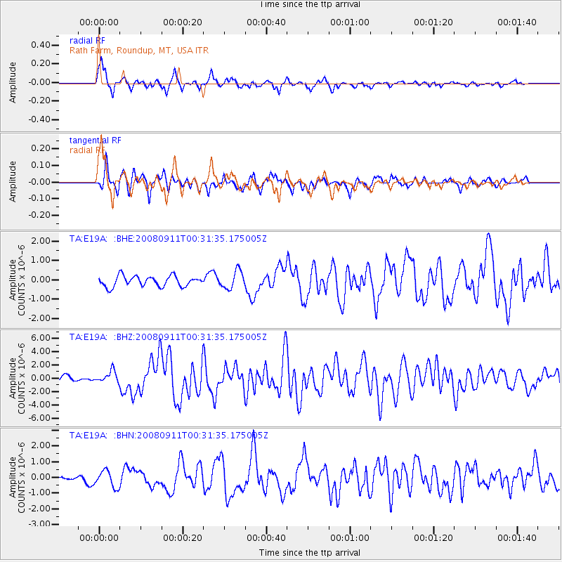
Signal To Noise
| Channel | StoN | STA | LTA |
| TA:E19A: :BHZ:20080911T00:31:35.175005Z | 2.548499 | 9.377811E-7 | 3.679739E-7 |
| TA:E19A: :BHN:20080911T00:31:35.175005Z | 2.5223885 | 5.316505E-7 | 2.1077267E-7 |
| TA:E19A: :BHE:20080911T00:31:35.175005Z | 1.7384721 | 4.6869775E-7 | 2.6960328E-7 |
| Arrivals |
| Ps | 5.9 SECOND |
| PpPs | 18 SECOND |
| PsPs/PpSs | 24 SECOND |


