You are here: Home > Network List > TA - USArray Transportable Network (new EarthScope stations) Stations List
> Station N30M Aishikik Lake, Yukon, CAN > Earthquake Result Viewer
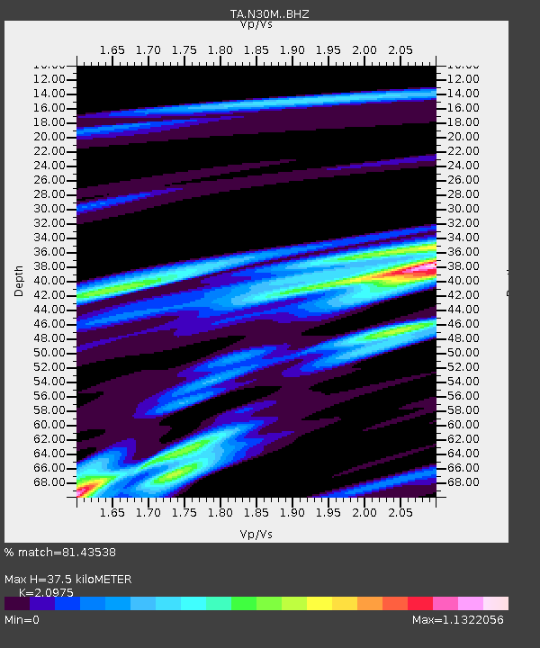
N30M Aishikik Lake, Yukon, CAN - Earthquake Result Viewer
| Earthquake location: |
Off Coast Of Northern Peru |
| Earthquake latitude/longitude: |
-10.0/-79.3 |
| Earthquake time(UTC): |
2019/03/31 (090) 15:27:57 GMT |
| Earthquake Depth: |
29 km |
| Earthquake Magnitude: |
5.5 Mww |
| Earthquake Catalog/Contributor: |
NEIC PDE/us |
|
| Network: |
TA USArray Transportable Network (new EarthScope stations) |
| Station: |
N30M Aishikik Lake, Yukon, CAN |
| Lat/Lon: |
61.46 N/137.09 W |
| Elevation: |
941 m |
|
| Distance: |
84.2 deg |
| Az: |
335.899 deg |
| Baz: |
123.112 deg |
| Ray Param: |
0.045634855 |
| Estimated Moho Depth: |
37.5 km |
| Estimated Crust Vp/Vs: |
2.10 |
| Assumed Crust Vp: |
6.566 km/s |
| Estimated Crust Vs: |
3.13 km/s |
| Estimated Crust Poisson's Ratio: |
0.35 |
|
| Radial Match: |
81.43538 % |
| Radial Bump: |
400 |
| Transverse Match: |
62.981674 % |
| Transverse Bump: |
400 |
| SOD ConfigId: |
13570011 |
| Insert Time: |
2019-05-02 20:44:31.138 +0000 |
| GWidth: |
2.5 |
| Max Bumps: |
400 |
| Tol: |
0.001 |
|

Signal To Noise
| Channel | StoN | STA | LTA |
| TA:N30M: :BHZ:20190331T15:39:55.049983Z | 5.5472054 | 5.7428923E-7 | 1.03527675E-7 |
| TA:N30M: :BHN:20190331T15:39:55.049983Z | 1.6273124 | 1.374751E-7 | 8.4479844E-8 |
| TA:N30M: :BHE:20190331T15:39:55.049983Z | 1.7523934 | 1.5957094E-7 | 9.105886E-8 |
| Arrivals |
| Ps | 6.4 SECOND |
| PpPs | 17 SECOND |
| PsPs/PpSs | 24 SECOND |


