You are here: Home > Network List > TA - USArray Transportable Network (new EarthScope stations) Stations List
> Station E19A Rath Farm, Roundup, MT, USA > Earthquake Result Viewer
E19A Rath Farm, Roundup, MT, USA - Earthquake Result Viewer
| Earthquake location: |
North Of Honduras |
| Earthquake latitude/longitude: |
16.7/-86.2 |
| Earthquake time(UTC): |
2009/05/28 (148) 08:24:45 GMT |
| Earthquake Depth: |
10 km |
| Earthquake Magnitude: |
6.7 MB, 7.2 MS, 7.3 MW, 7.3 MW |
| Earthquake Catalog/Contributor: |
WHDF/NEIC |
|
| Network: |
TA USArray Transportable Network (new EarthScope stations) |
| Station: |
E19A Rath Farm, Roundup, MT, USA |
| Lat/Lon: |
46.46 N/108.79 W |
| Elevation: |
1059 m |
|
| Distance: |
35.1 deg |
| Az: |
332.527 deg |
| Baz: |
140.245 deg |
| Ray Param: |
0.07741052 |
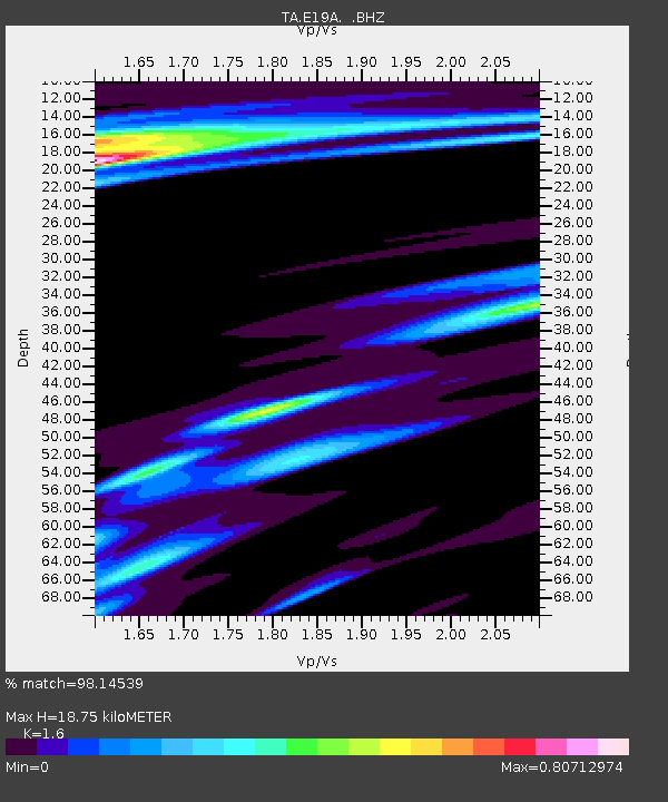
| Estimated Moho Depth: |
18.75 km |
| Estimated Crust Vp/Vs: |
1.60 |
| Assumed Crust Vp: |
6.518 km/s |
| Estimated Crust Vs: |
4.074 km/s |
| Estimated Crust Poisson's Ratio: |
0.18 |
|
| Radial Match: |
98.14539 % |
| Radial Bump: |
269 |
| Transverse Match: |
91.70771 % |
| Transverse Bump: |
398 |
| SOD ConfigId: |
2648 |
| Insert Time: |
2010-03-06 21:13:48.926 +0000 |
| GWidth: |
2.5 |
| Max Bumps: |
400 |
| Tol: |
0.001 |
|

Signal To Noise
| Channel | StoN | STA | LTA |
| TA:E19A: :BHZ:20090528T08:31:07.448988Z | 15.916986 | 1.3949482E-6 | 8.7638966E-8 |
| TA:E19A: :BHN:20090528T08:31:07.448988Z | 4.469502 | 6.545166E-7 | 1.4644061E-7 |
| TA:E19A: :BHE:20090528T08:31:07.448988Z | 4.2747526 | 4.245249E-7 | 9.930982E-8 |
| Arrivals |
| Ps | 1.9 SECOND |
| PpPs | 6.9 SECOND |
| PsPs/PpSs | 8.7 SECOND |


