You are here: Home > Network List > TS - TERRAscope (Southern California Seismic Network) Stations List
> Station DGR Domenigoni Valley Reservior, California, USA > Earthquake Result Viewer
DGR Domenigoni Valley Reservior, California, USA - Earthquake Result Viewer
| Earthquake location: |
Jujuy Province, Argentina |
| Earthquake latitude/longitude: |
-23.0/-66.3 |
| Earthquake time(UTC): |
1997/07/20 (201) 10:14:22 GMT |
| Earthquake Depth: |
256 km |
| Earthquake Magnitude: |
5.7 MB, 6.1 UNKNOWN, 5.7 ME |
| Earthquake Catalog/Contributor: |
WHDF/NEIC |
|
| Network: |
TS TERRAscope (Southern California Seismic Network) |
| Station: |
DGR Domenigoni Valley Reservior, California, USA |
| Lat/Lon: |
33.65 N/117.01 W |
| Elevation: |
700 m |
|
| Distance: |
74.2 deg |
| Az: |
317.856 deg |
| Baz: |
132.156 deg |
| Ray Param: |
0.051807567 |
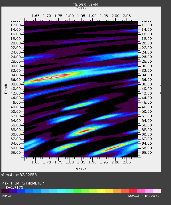
| Estimated Moho Depth: |
34.75 km |
| Estimated Crust Vp/Vs: |
1.72 |
| Assumed Crust Vp: |
6.264 km/s |
| Estimated Crust Vs: |
3.647 km/s |
| Estimated Crust Poisson's Ratio: |
0.24 |
|
| Radial Match: |
83.22858 % |
| Radial Bump: |
400 |
| Transverse Match: |
81.18875 % |
| Transverse Bump: |
400 |
| SOD ConfigId: |
6273 |
| Insert Time: |
2010-02-26 14:09:49.103 +0000 |
| GWidth: |
2.5 |
| Max Bumps: |
400 |
| Tol: |
0.001 |
|

Signal To Noise
| Channel | StoN | STA | LTA |
| TS:DGR: :BHN:19970720T10:25:00.378003Z | 3.715557 | 3.7052124E-7 | 9.972158E-8 |
| TS:DGR: :BHE:19970720T10:25:00.378003Z | 6.0296073 | 4.5029654E-7 | 7.468091E-8 |
| TS:DGR: :BHZ:19970720T10:25:00.378003Z | 14.182409 | 1.1904617E-6 | 8.393931E-8 |
| Arrivals |
| Ps | 4.1 SECOND |
| PpPs | 15 SECOND |
| PsPs/PpSs | 19 SECOND |


