You are here: Home > Network List > TA - USArray Transportable Network (new EarthScope stations) Stations List
> Station E19A Rath Farm, Roundup, MT, USA > Earthquake Result Viewer
E19A Rath Farm, Roundup, MT, USA - Earthquake Result Viewer

| Earthquake location: |
Northern Mid-Atlantic Ridge |
| Earthquake latitude/longitude: |
23.9/-46.1 |
| Earthquake time(UTC): |
2009/06/06 (157) 20:33:28 GMT |
| Earthquake Depth: |
14 km |
| Earthquake Magnitude: |
6.0 MB, 5.7 MS, 6.0 MW, 6.0 MW |
| Earthquake Catalog/Contributor: |
WHDF/NEIC |
|
| Network: |
TA USArray Transportable Network (new EarthScope stations) |
| Station: |
E19A Rath Farm, Roundup, MT, USA |
| Lat/Lon: |
46.46 N/108.79 W |
| Elevation: |
1059 m |
|
| Distance: |
54.5 deg |
| Az: |
311.001 deg |
| Baz: |
91.796 deg |
| Ray Param: |
0.065419585 |
| Estimated Moho Depth: |
32.75 km |
| Estimated Crust Vp/Vs: |
2.10 |
| Assumed Crust Vp: |
6.518 km/s |
| Estimated Crust Vs: |
3.111 km/s |
| Estimated Crust Poisson's Ratio: |
0.35 |
|
| Radial Match: |
88.56842 % |
| Radial Bump: |
400 |
| Transverse Match: |
83.491325 % |
| Transverse Bump: |
400 |
| SOD ConfigId: |
2648 |
| Insert Time: |
2010-03-06 21:13:54.405 +0000 |
| GWidth: |
2.5 |
| Max Bumps: |
400 |
| Tol: |
0.001 |
|
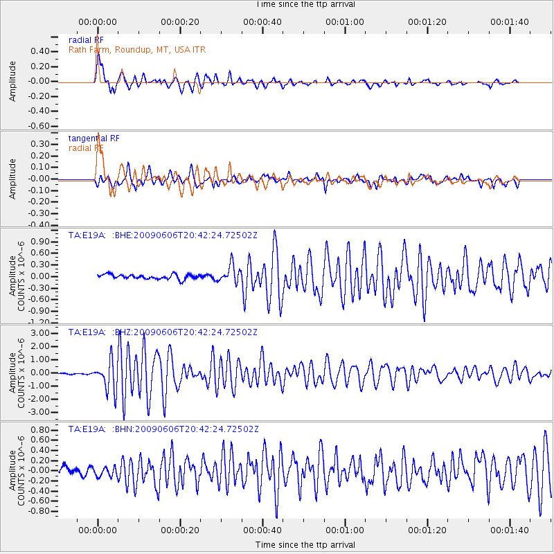
Signal To Noise
| Channel | StoN | STA | LTA |
| TA:E19A: :BHZ:20090606T20:42:24.72502Z | 22.091084 | 1.1295533E-6 | 5.1131636E-8 |
| TA:E19A: :BHN:20090606T20:42:24.72502Z | 1.097997 | 8.704358E-8 | 7.927488E-8 |
| TA:E19A: :BHE:20090606T20:42:24.72502Z | 3.7943442 | 2.2960447E-7 | 6.05123E-8 |
| Arrivals |
| Ps | 5.8 SECOND |
| PpPs | 15 SECOND |
| PsPs/PpSs | 21 SECOND |


