You are here: Home > Network List > UW - Pacific Northwest Regional Seismic Network Stations List
> Station UMAT Pilot Rock, OR, USA > Earthquake Result Viewer
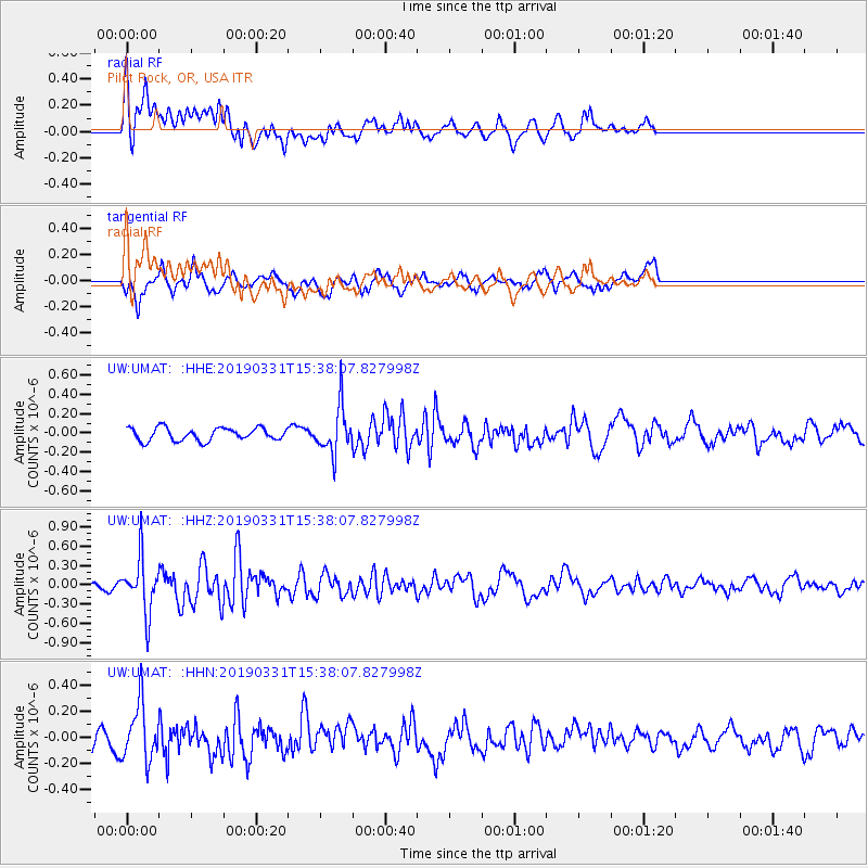
UMAT Pilot Rock, OR, USA - Earthquake Result Viewer
*The percent match for this event was below the threshold and hence no stack was calculated.
| Earthquake location: |
Off Coast Of Northern Peru |
| Earthquake latitude/longitude: |
-10.0/-79.3 |
| Earthquake time(UTC): |
2019/03/31 (090) 15:27:57 GMT |
| Earthquake Depth: |
29 km |
| Earthquake Magnitude: |
5.5 Mww |
| Earthquake Catalog/Contributor: |
NEIC PDE/us |
|
| Network: |
UW Pacific Northwest Regional Seismic Network |
| Station: |
UMAT Pilot Rock, OR, USA |
| Lat/Lon: |
45.29 N/118.96 W |
| Elevation: |
1318 m |
|
| Distance: |
65.6 deg |
| Az: |
330.355 deg |
| Baz: |
136.349 deg |
| Ray Param: |
$rayparam |
*The percent match for this event was below the threshold and hence was not used in the summary stack. |
|
| Radial Match: |
72.016045 % |
| Radial Bump: |
400 |
| Transverse Match: |
61.18846 % |
| Transverse Bump: |
395 |
| SOD ConfigId: |
13570011 |
| Insert Time: |
2019-05-02 20:45:51.683 +0000 |
| GWidth: |
2.5 |
| Max Bumps: |
400 |
| Tol: |
0.001 |
|
Signal To Noise
| Channel | StoN | STA | LTA |
| UW:UMAT: :HHZ:20190331T15:38:07.827998Z | 3.210398 | 4.1799348E-7 | 1.301999E-7 |
| UW:UMAT: :HHN:20190331T15:38:07.827998Z | 1.6815934 | 2.13297E-7 | 1.268422E-7 |
| UW:UMAT: :HHE:20190331T15:38:07.827998Z | 3.6957996 | 2.4343484E-7 | 6.586797E-8 |
| Arrivals |
| Ps | |
| PpPs | |
| PsPs/PpSs | |


