You are here: Home > Network List > TA - USArray Transportable Network (new EarthScope stations) Stations List
> Station E19A Rath Farm, Roundup, MT, USA > Earthquake Result Viewer
E19A Rath Farm, Roundup, MT, USA - Earthquake Result Viewer

| Earthquake location: |
Guatemala |
| Earthquake latitude/longitude: |
14.6/-91.2 |
| Earthquake time(UTC): |
2009/05/03 (123) 16:21:47 GMT |
| Earthquake Depth: |
124 km |
| Earthquake Magnitude: |
5.6 MB, 6.2 MW, 6.2 MW |
| Earthquake Catalog/Contributor: |
WHDF/NEIC |
|
| Network: |
TA USArray Transportable Network (new EarthScope stations) |
| Station: |
E19A Rath Farm, Roundup, MT, USA |
| Lat/Lon: |
46.46 N/108.79 W |
| Elevation: |
1059 m |
|
| Distance: |
35.1 deg |
| Az: |
338.639 deg |
| Baz: |
149.324 deg |
| Ray Param: |
0.07701048 |
| Estimated Moho Depth: |
49.75 km |
| Estimated Crust Vp/Vs: |
1.62 |
| Assumed Crust Vp: |
6.518 km/s |
| Estimated Crust Vs: |
4.036 km/s |
| Estimated Crust Poisson's Ratio: |
0.19 |
|
| Radial Match: |
88.62876 % |
| Radial Bump: |
321 |
| Transverse Match: |
48.488594 % |
| Transverse Bump: |
352 |
| SOD ConfigId: |
2658 |
| Insert Time: |
2010-03-06 21:14:08.883 +0000 |
| GWidth: |
2.5 |
| Max Bumps: |
400 |
| Tol: |
0.001 |
|
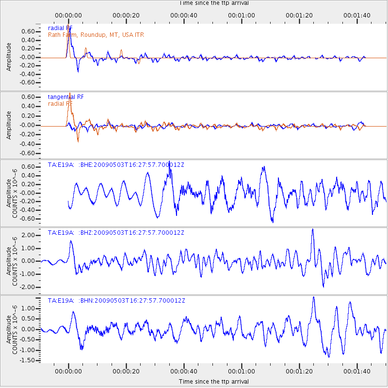
Signal To Noise
| Channel | StoN | STA | LTA |
| TA:E19A: :BHZ:20090503T16:27:57.700012Z | 11.035863 | 8.0305557E-7 | 7.276781E-8 |
| TA:E19A: :BHN:20090503T16:27:57.700012Z | 5.948591 | 5.2155764E-7 | 8.7677506E-8 |
| TA:E19A: :BHE:20090503T16:27:57.700012Z | 2.2483013 | 3.6076383E-7 | 1.6046062E-7 |
| Arrivals |
| Ps | 5.1 SECOND |
| PpPs | 18 SECOND |
| PsPs/PpSs | 23 SECOND |


