You are here: Home > Network List > TA - USArray Transportable Network (new EarthScope stations) Stations List
> Station E19A Rath Farm, Roundup, MT, USA > Earthquake Result Viewer
E19A Rath Farm, Roundup, MT, USA - Earthquake Result Viewer
| Earthquake location: |
Kuril Islands |
| Earthquake latitude/longitude: |
46.0/151.4 |
| Earthquake time(UTC): |
2009/04/18 (108) 19:17:58 GMT |
| Earthquake Depth: |
35 km |
| Earthquake Magnitude: |
6.3 MB, 6.3 MS, 6.6 MW, 6.4 MW |
| Earthquake Catalog/Contributor: |
WHDF/NEIC |
|
| Network: |
TA USArray Transportable Network (new EarthScope stations) |
| Station: |
E19A Rath Farm, Roundup, MT, USA |
| Lat/Lon: |
46.46 N/108.79 W |
| Elevation: |
1059 m |
|
| Distance: |
64.1 deg |
| Az: |
49.208 deg |
| Baz: |
310.25 deg |
| Ray Param: |
0.05906324 |
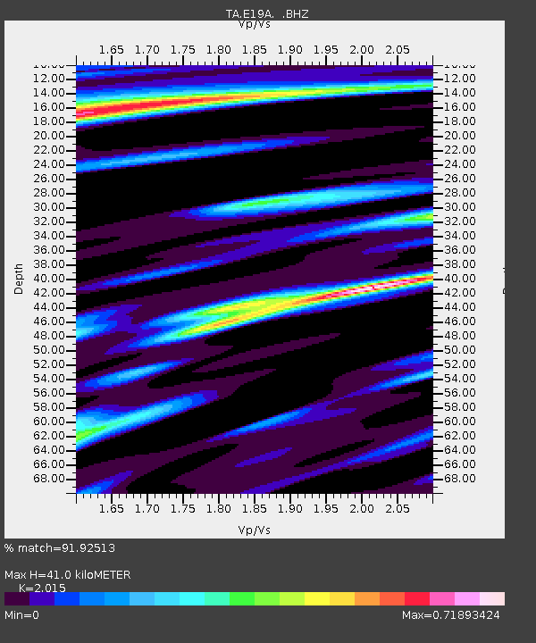
| Estimated Moho Depth: |
41.0 km |
| Estimated Crust Vp/Vs: |
2.02 |
| Assumed Crust Vp: |
6.518 km/s |
| Estimated Crust Vs: |
3.235 km/s |
| Estimated Crust Poisson's Ratio: |
0.34 |
|
| Radial Match: |
91.92513 % |
| Radial Bump: |
350 |
| Transverse Match: |
82.43033 % |
| Transverse Bump: |
400 |
| SOD ConfigId: |
2760 |
| Insert Time: |
2010-03-06 21:14:12.934 +0000 |
| GWidth: |
2.5 |
| Max Bumps: |
400 |
| Tol: |
0.001 |
|

Signal To Noise
| Channel | StoN | STA | LTA |
| TA:E19A: :BHZ:20090418T19:27:58.924019Z | 17.556849 | 2.2441325E-6 | 1.2782093E-7 |
| TA:E19A: :BHN:20090418T19:27:58.924019Z | 1.7232038 | 3.9456697E-7 | 2.2897291E-7 |
| TA:E19A: :BHE:20090418T19:27:58.924019Z | 2.7207663 | 4.943204E-7 | 1.8168424E-7 |
| Arrivals |
| Ps | 6.6 SECOND |
| PpPs | 18 SECOND |
| PsPs/PpSs | 25 SECOND |


