You are here: Home > Network List > US - United States National Seismic Network Stations List
> Station HAWA Hanford, Washington, USA > Earthquake Result Viewer
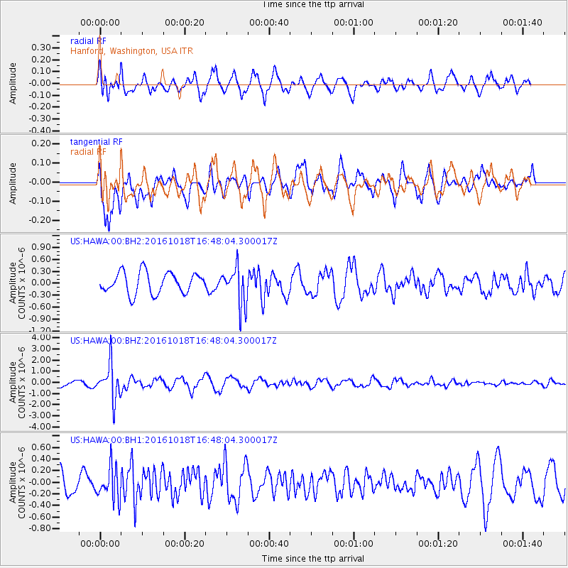
HAWA Hanford, Washington, USA - Earthquake Result Viewer
*The percent match for this event was below the threshold and hence no stack was calculated.
| Earthquake location: |
South Of Fiji Islands |
| Earthquake latitude/longitude: |
-23.3/-179.9 |
| Earthquake time(UTC): |
2016/10/18 (292) 16:36:41 GMT |
| Earthquake Depth: |
540 km |
| Earthquake Magnitude: |
5.9 MWW, 6.0 MWB |
| Earthquake Catalog/Contributor: |
NEIC PDE/NEIC COMCAT |
|
| Network: |
US United States National Seismic Network |
| Station: |
HAWA Hanford, Washington, USA |
| Lat/Lon: |
46.39 N/119.53 W |
| Elevation: |
364 m |
|
| Distance: |
88.3 deg |
| Az: |
37.013 deg |
| Baz: |
233.087 deg |
| Ray Param: |
$rayparam |
*The percent match for this event was below the threshold and hence was not used in the summary stack. |
|
| Radial Match: |
69.108086 % |
| Radial Bump: |
400 |
| Transverse Match: |
53.96955 % |
| Transverse Bump: |
400 |
| SOD ConfigId: |
1815711 |
| Insert Time: |
2016-11-01 16:39:23.435 +0000 |
| GWidth: |
2.5 |
| Max Bumps: |
400 |
| Tol: |
0.001 |
|
Signal To Noise
| Channel | StoN | STA | LTA |
| US:HAWA:00:BHZ:20161018T16:48:04.300017Z | 5.9824753 | 1.6079222E-6 | 2.6877206E-7 |
| US:HAWA:00:BH1:20161018T16:48:04.300017Z | 1.0446743 | 2.7829978E-7 | 2.6639862E-7 |
| US:HAWA:00:BH2:20161018T16:48:04.300017Z | 1.8478078 | 4.9166186E-7 | 2.660785E-7 |
| Arrivals |
| Ps | |
| PpPs | |
| PsPs/PpSs | |


