You are here: Home > Network List > TS - TERRAscope (Southern California Seismic Network) Stations List
> Station DGR Domenigoni Valley Reservior, California, USA > Earthquake Result Viewer
DGR Domenigoni Valley Reservior, California, USA - Earthquake Result Viewer
| Earthquake location: |
Near Coast Of Central Chile |
| Earthquake latitude/longitude: |
-30.5/-71.9 |
| Earthquake time(UTC): |
1997/07/25 (206) 06:47:02 GMT |
| Earthquake Depth: |
33 km |
| Earthquake Magnitude: |
5.6 MB, 5.5 MS, 6.3 UNKNOWN |
| Earthquake Catalog/Contributor: |
WHDF/NEIC |
|
| Network: |
TS TERRAscope (Southern California Seismic Network) |
| Station: |
DGR Domenigoni Valley Reservior, California, USA |
| Lat/Lon: |
33.65 N/117.01 W |
| Elevation: |
700 m |
|
| Distance: |
76.7 deg |
| Az: |
322.613 deg |
| Baz: |
141.059 deg |
| Ray Param: |
0.05077599 |
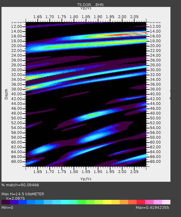
| Estimated Moho Depth: |
14.5 km |
| Estimated Crust Vp/Vs: |
2.10 |
| Assumed Crust Vp: |
6.264 km/s |
| Estimated Crust Vs: |
2.986 km/s |
| Estimated Crust Poisson's Ratio: |
0.35 |
|
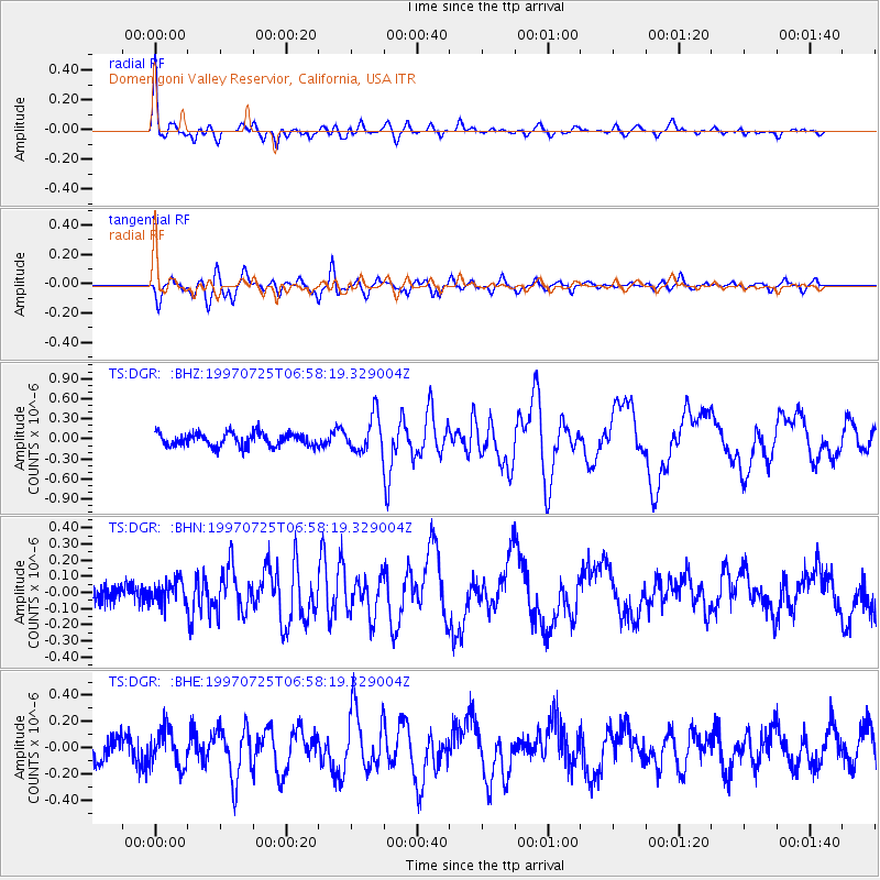
| Radial Match: |
90.09466 % |
| Radial Bump: |
334 |
| Transverse Match: |
77.14512 % |
| Transverse Bump: |
400 |
| SOD ConfigId: |
6273 |
| Insert Time: |
2010-02-26 14:09:51.202 +0000 |
| GWidth: |
2.5 |
| Max Bumps: |
400 |
| Tol: |
0.001 |
|
Signal To Noise
| Channel | StoN | STA | LTA |
| TS:DGR: :BHN:19970725T06:58:19.329004Z | 1.0196613 | 7.1422164E-8 | 7.004499E-8 |
| TS:DGR: :BHE:19970725T06:58:19.329004Z | 1.6808732 | 1.4044429E-7 | 8.3554355E-8 |
| TS:DGR: :BHZ:19970725T06:58:19.329004Z | 2.6982946 | 2.6635288E-7 | 9.871157E-8 |
| Arrivals |
| Ps | 2.6 SECOND |
| PpPs | 7.0 SECOND |
| PsPs/PpSs | 9.6 SECOND |


