You are here: Home > Network List > TA - USArray Transportable Network (new EarthScope stations) Stations List
> Station B18K Kokolik River, AK, USA > Earthquake Result Viewer
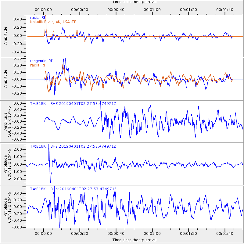
B18K Kokolik River, AK, USA - Earthquake Result Viewer
*The percent match for this event was below the threshold and hence no stack was calculated.
| Earthquake location: |
Leyte, Philippines |
| Earthquake latitude/longitude: |
10.6/125.9 |
| Earthquake time(UTC): |
2019/04/01 (091) 02:16:53 GMT |
| Earthquake Depth: |
58 km |
| Earthquake Magnitude: |
5.5 Mww |
| Earthquake Catalog/Contributor: |
NEIC PDE/us |
|
| Network: |
TA USArray Transportable Network (new EarthScope stations) |
| Station: |
B18K Kokolik River, AK, USA |
| Lat/Lon: |
69.36 N/161.80 W |
| Elevation: |
222 m |
|
| Distance: |
73.9 deg |
| Az: |
20.578 deg |
| Baz: |
257.103 deg |
| Ray Param: |
$rayparam |
*The percent match for this event was below the threshold and hence was not used in the summary stack. |
|
| Radial Match: |
78.35904 % |
| Radial Bump: |
400 |
| Transverse Match: |
69.0645 % |
| Transverse Bump: |
400 |
| SOD ConfigId: |
13570011 |
| Insert Time: |
2019-05-02 20:50:06.185 +0000 |
| GWidth: |
2.5 |
| Max Bumps: |
400 |
| Tol: |
0.001 |
|
Signal To Noise
| Channel | StoN | STA | LTA |
| TA:B18K: :BHZ:20190401T02:27:53.474971Z | 7.2750483 | 1.0159637E-6 | 1.3965045E-7 |
| TA:B18K: :BHN:20190401T02:27:53.474971Z | 1.1895854 | 1.7623854E-7 | 1.4815123E-7 |
| TA:B18K: :BHE:20190401T02:27:53.474971Z | 2.3105047 | 2.2429106E-7 | 9.7074484E-8 |
| Arrivals |
| Ps | |
| PpPs | |
| PsPs/PpSs | |


