You are here: Home > Network List > UU - University of Utah Regional Network Stations List
> Station FORU South Mineral Mountains, UT, USA > Earthquake Result Viewer
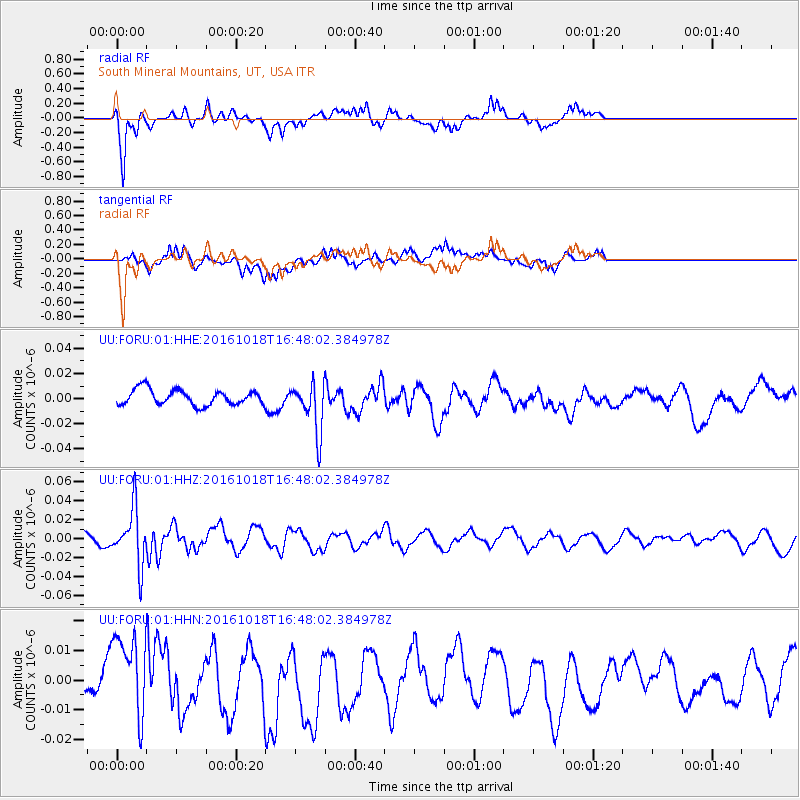
FORU South Mineral Mountains, UT, USA - Earthquake Result Viewer
*The percent match for this event was below the threshold and hence no stack was calculated.
| Earthquake location: |
South Of Fiji Islands |
| Earthquake latitude/longitude: |
-23.3/-179.9 |
| Earthquake time(UTC): |
2016/10/18 (292) 16:36:41 GMT |
| Earthquake Depth: |
540 km |
| Earthquake Magnitude: |
5.9 MWW, 6.0 MWB |
| Earthquake Catalog/Contributor: |
NEIC PDE/NEIC COMCAT |
|
| Network: |
UU University of Utah Regional Network |
| Station: |
FORU South Mineral Mountains, UT, USA |
| Lat/Lon: |
38.46 N/112.86 W |
| Elevation: |
1840 m |
|
| Distance: |
87.8 deg |
| Az: |
46.343 deg |
| Baz: |
237.903 deg |
| Ray Param: |
$rayparam |
*The percent match for this event was below the threshold and hence was not used in the summary stack. |
|
| Radial Match: |
82.871826 % |
| Radial Bump: |
332 |
| Transverse Match: |
74.796036 % |
| Transverse Bump: |
400 |
| SOD ConfigId: |
1815711 |
| Insert Time: |
2016-11-01 16:39:59.270 +0000 |
| GWidth: |
2.5 |
| Max Bumps: |
400 |
| Tol: |
0.001 |
|
Signal To Noise
| Channel | StoN | STA | LTA |
| UU:FORU:01:HHZ:20161018T16:48:02.384978Z | 5.7056203 | 2.9384431E-8 | 5.1500852E-9 |
| UU:FORU:01:HHN:20161018T16:48:02.384978Z | 2.457082 | 1.4816222E-8 | 6.030007E-9 |
| UU:FORU:01:HHE:20161018T16:48:02.384978Z | 3.297112 | 1.9918332E-8 | 6.041145E-9 |
| Arrivals |
| Ps | |
| PpPs | |
| PsPs/PpSs | |


