You are here: Home > Network List > TS - TERRAscope (Southern California Seismic Network) Stations List
> Station DGR Domenigoni Valley Reservior, California, USA > Earthquake Result Viewer
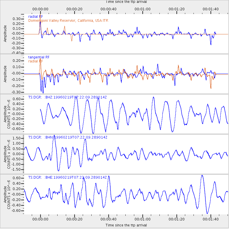
DGR Domenigoni Valley Reservior, California, USA - Earthquake Result Viewer
*The percent match for this event was below the threshold and hence no stack was calculated.
| Earthquake location: |
Off Coast Of Southern Chile |
| Earthquake latitude/longitude: |
-42.1/-75.1 |
| Earthquake time(UTC): |
1996/02/19 (050) 07:10:10 GMT |
| Earthquake Depth: |
33 km |
| Earthquake Magnitude: |
5.9 MB, 5.3 MS, 5.9 UNKNOWN, 5.9 MW |
| Earthquake Catalog/Contributor: |
WHDF/NEIC |
|
| Network: |
TS TERRAscope (Southern California Seismic Network) |
| Station: |
DGR Domenigoni Valley Reservior, California, USA |
| Lat/Lon: |
33.65 N/117.01 W |
| Elevation: |
700 m |
|
| Distance: |
84.6 deg |
| Az: |
325.959 deg |
| Baz: |
150.033 deg |
| Ray Param: |
$rayparam |
*The percent match for this event was below the threshold and hence was not used in the summary stack. |
|
| Radial Match: |
65.06326 % |
| Radial Bump: |
363 |
| Transverse Match: |
59.140987 % |
| Transverse Bump: |
400 |
| SOD ConfigId: |
4480 |
| Insert Time: |
2010-02-26 14:09:56.601 +0000 |
| GWidth: |
2.5 |
| Max Bumps: |
400 |
| Tol: |
0.001 |
|
Signal To Noise
| Channel | StoN | STA | LTA |
| TS:DGR: :BHN:19960219T07:22:09.289014Z | 0.99296236 | 3.8378047E-7 | 3.8650052E-7 |
| TS:DGR: :BHE:19960219T07:22:09.289014Z | 0.2614067 | 6.9981134E-8 | 2.6770982E-7 |
| TS:DGR: :BHZ:19960219T07:22:09.289014Z | 1.531341 | 4.980619E-7 | 3.2524562E-7 |
| Arrivals |
| Ps | |
| PpPs | |
| PsPs/PpSs | |


