You are here: Home > Network List > TA - USArray Transportable Network (new EarthScope stations) Stations List
> Station S13A Holt Ranch, Enterprise, UT, USA > Earthquake Result Viewer
S13A Holt Ranch, Enterprise, UT, USA - Earthquake Result Viewer
| Earthquake location: |
South Of Panama |
| Earthquake latitude/longitude: |
6.9/-82.4 |
| Earthquake time(UTC): |
2008/01/24 (024) 04:12:13 GMT |
| Earthquake Depth: |
10 km |
| Earthquake Magnitude: |
5.8 MW, 5.3 MS, 5.3 MB, 5.8 MW |
| Earthquake Catalog/Contributor: |
WHDF/NEIC |
|
| Network: |
TA USArray Transportable Network (new EarthScope stations) |
| Station: |
S13A Holt Ranch, Enterprise, UT, USA |
| Lat/Lon: |
37.58 N/113.86 W |
| Elevation: |
1698 m |
|
| Distance: |
41.8 deg |
| Az: |
321.501 deg |
| Baz: |
128.934 deg |
| Ray Param: |
0.07356851 |
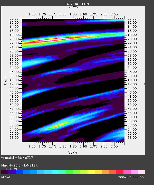
| Estimated Moho Depth: |
20.0 km |
| Estimated Crust Vp/Vs: |
1.76 |
| Assumed Crust Vp: |
6.194 km/s |
| Estimated Crust Vs: |
3.519 km/s |
| Estimated Crust Poisson's Ratio: |
0.26 |
|
| Radial Match: |
86.46717 % |
| Radial Bump: |
378 |
| Transverse Match: |
75.19474 % |
| Transverse Bump: |
400 |
| SOD ConfigId: |
2564 |
| Insert Time: |
2010-03-06 21:16:28.245 +0000 |
| GWidth: |
2.5 |
| Max Bumps: |
400 |
| Tol: |
0.001 |
|

Signal To Noise
| Channel | StoN | STA | LTA |
| TA:S13A: :BHN:20080124T04:19:32.473013Z | 0.71367335 | 9.5346216E-8 | 1.3359924E-7 |
| TA:S13A: :BHE:20080124T04:19:32.473013Z | 0.6535055 | 1.5174145E-7 | 2.3219611E-7 |
| TA:S13A: :BHZ:20080124T04:19:32.473013Z | 1.5924318 | 3.7034545E-7 | 2.3256598E-7 |
| Arrivals |
| Ps | 2.6 SECOND |
| PpPs | 8.4 SECOND |
| PsPs/PpSs | 11 SECOND |


