You are here: Home > Network List > TA - USArray Transportable Network (new EarthScope stations) Stations List
> Station S13A Holt Ranch, Enterprise, UT, USA > Earthquake Result Viewer
S13A Holt Ranch, Enterprise, UT, USA - Earthquake Result Viewer
| Earthquake location: |
Mariana Islands |
| Earthquake latitude/longitude: |
18.9/145.4 |
| Earthquake time(UTC): |
2007/10/31 (304) 03:30:17 GMT |
| Earthquake Depth: |
223 km |
| Earthquake Magnitude: |
6.2 MB, 7.2 MW, 7.2 MW |
| Earthquake Catalog/Contributor: |
WHDF/NEIC |
|
| Network: |
TA USArray Transportable Network (new EarthScope stations) |
| Station: |
S13A Holt Ranch, Enterprise, UT, USA |
| Lat/Lon: |
37.58 N/113.86 W |
| Elevation: |
1698 m |
|
| Distance: |
86.9 deg |
| Az: |
51.41 deg |
| Baz: |
291.334 deg |
| Ray Param: |
0.043222483 |
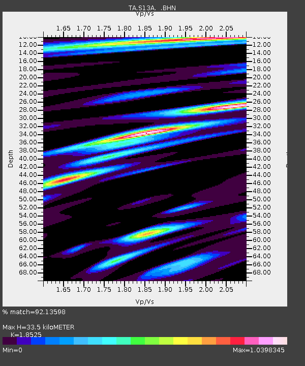
| Estimated Moho Depth: |
33.5 km |
| Estimated Crust Vp/Vs: |
1.85 |
| Assumed Crust Vp: |
6.194 km/s |
| Estimated Crust Vs: |
3.344 km/s |
| Estimated Crust Poisson's Ratio: |
0.29 |
|
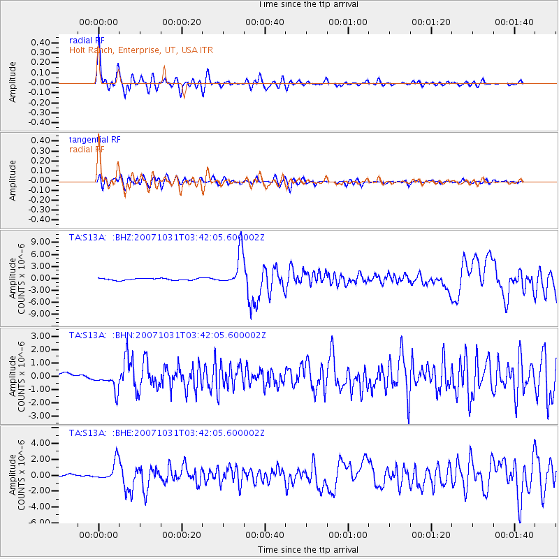
| Radial Match: |
92.13598 % |
| Radial Bump: |
400 |
| Transverse Match: |
70.4848 % |
| Transverse Bump: |
400 |
| SOD ConfigId: |
2564 |
| Insert Time: |
2010-03-06 21:16:44.937 +0000 |
| GWidth: |
2.5 |
| Max Bumps: |
400 |
| Tol: |
0.001 |
|
Signal To Noise
| Channel | StoN | STA | LTA |
| TA:S13A: :BHN:20071031T03:42:05.600002Z | 2.817682 | 7.380849E-7 | 2.6194755E-7 |
| TA:S13A: :BHE:20071031T03:42:05.600002Z | 9.728311 | 1.2839386E-6 | 1.319796E-7 |
| TA:S13A: :BHZ:20071031T03:42:05.600002Z | 19.764524 | 4.489433E-6 | 2.2714602E-7 |
| Arrivals |
| Ps | 4.7 SECOND |
| PpPs | 15 SECOND |
| PsPs/PpSs | 20 SECOND |


