You are here: Home > Network List > TA - USArray Transportable Network (new EarthScope stations) Stations List
> Station S13A Holt Ranch, Enterprise, UT, USA > Earthquake Result Viewer
S13A Holt Ranch, Enterprise, UT, USA - Earthquake Result Viewer
| Earthquake location: |
Jujuy Province, Argentina |
| Earthquake latitude/longitude: |
-22.2/-65.8 |
| Earthquake time(UTC): |
2007/07/21 (202) 15:34:52 GMT |
| Earthquake Depth: |
290 km |
| Earthquake Magnitude: |
5.8 MB, 6.4 MW, 6.3 MW |
| Earthquake Catalog/Contributor: |
WHDF/NEIC |
|
| Network: |
TA USArray Transportable Network (new EarthScope stations) |
| Station: |
S13A Holt Ranch, Enterprise, UT, USA |
| Lat/Lon: |
37.58 N/113.86 W |
| Elevation: |
1698 m |
|
| Distance: |
74.7 deg |
| Az: |
322.194 deg |
| Baz: |
134.332 deg |
| Ray Param: |
0.051372312 |
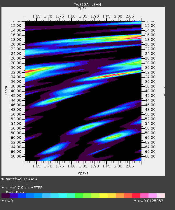
| Estimated Moho Depth: |
17.0 km |
| Estimated Crust Vp/Vs: |
2.10 |
| Assumed Crust Vp: |
6.194 km/s |
| Estimated Crust Vs: |
2.953 km/s |
| Estimated Crust Poisson's Ratio: |
0.35 |
|
| Radial Match: |
93.94494 % |
| Radial Bump: |
361 |
| Transverse Match: |
81.894684 % |
| Transverse Bump: |
400 |
| SOD ConfigId: |
2564 |
| Insert Time: |
2010-03-06 21:17:18.402 +0000 |
| GWidth: |
2.5 |
| Max Bumps: |
400 |
| Tol: |
0.001 |
|
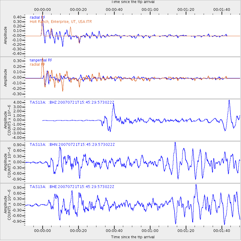
Signal To Noise
| Channel | StoN | STA | LTA |
| TA:S13A: :BHN:20070721T15:45:29.573022Z | 2.2094228 | 1.0778824E-7 | 4.87857E-8 |
| TA:S13A: :BHE:20070721T15:45:29.573022Z | 2.6050491 | 1.0351822E-7 | 3.9737532E-8 |
| TA:S13A: :BHZ:20070721T15:45:29.573022Z | 8.890236 | 4.2633746E-7 | 4.7955695E-8 |
| Arrivals |
| Ps | 3.1 SECOND |
| PpPs | 8.3 SECOND |
| PsPs/PpSs | 11 SECOND |


