You are here: Home > Network List > TA - USArray Transportable Network (new EarthScope stations) Stations List
> Station S13A Holt Ranch, Enterprise, UT, USA > Earthquake Result Viewer
S13A Holt Ranch, Enterprise, UT, USA - Earthquake Result Viewer
| Earthquake location: |
Peru-Brazil Border Region |
| Earthquake latitude/longitude: |
-7.9/-74.4 |
| Earthquake time(UTC): |
2007/07/12 (193) 05:23:49 GMT |
| Earthquake Depth: |
152 km |
| Earthquake Magnitude: |
5.9 MB, 6.1 MW, 6.0 MW |
| Earthquake Catalog/Contributor: |
WHDF/NEIC |
|
| Network: |
TA USArray Transportable Network (new EarthScope stations) |
| Station: |
S13A Holt Ranch, Enterprise, UT, USA |
| Lat/Lon: |
37.58 N/113.86 W |
| Elevation: |
1698 m |
|
| Distance: |
58.4 deg |
| Az: |
323.619 deg |
| Baz: |
132.307 deg |
| Ray Param: |
0.062399045 |
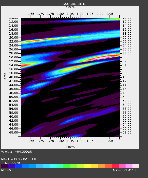
| Estimated Moho Depth: |
30.0 km |
| Estimated Crust Vp/Vs: |
2.01 |
| Assumed Crust Vp: |
6.194 km/s |
| Estimated Crust Vs: |
3.086 km/s |
| Estimated Crust Poisson's Ratio: |
0.33 |
|
| Radial Match: |
94.20065 % |
| Radial Bump: |
400 |
| Transverse Match: |
86.06783 % |
| Transverse Bump: |
400 |
| SOD ConfigId: |
2564 |
| Insert Time: |
2010-03-06 21:17:33.520 +0000 |
| GWidth: |
2.5 |
| Max Bumps: |
400 |
| Tol: |
0.001 |
|

Signal To Noise
| Channel | StoN | STA | LTA |
| TA:S13A: :BHN:20070712T05:32:58.10001Z | 5.8800993 | 2.2392976E-7 | 3.808265E-8 |
| TA:S13A: :BHE:20070712T05:32:58.10001Z | 4.081051 | 2.0194825E-7 | 4.9484374E-8 |
| TA:S13A: :BHZ:20070712T05:32:58.10001Z | 13.042672 | 6.9181505E-7 | 5.304243E-8 |
| Arrivals |
| Ps | 5.1 SECOND |
| PpPs | 14 SECOND |
| PsPs/PpSs | 19 SECOND |


