You are here: Home > Network List > TA - USArray Transportable Network (new EarthScope stations) Stations List
> Station S13A Holt Ranch, Enterprise, UT, USA > Earthquake Result Viewer
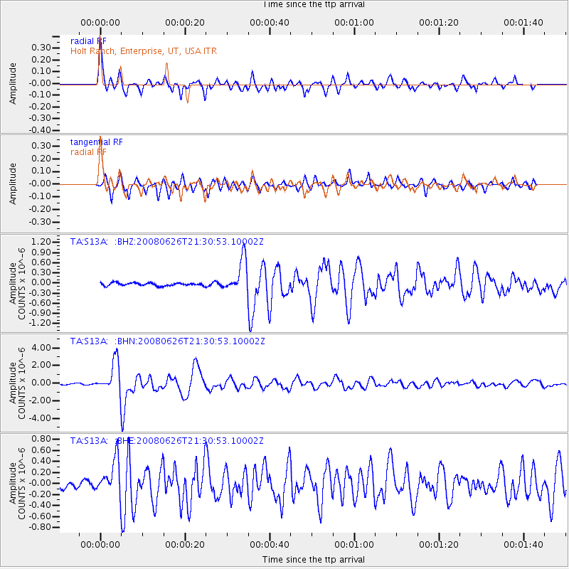
S13A Holt Ranch, Enterprise, UT, USA - Earthquake Result Viewer
| Earthquake location: |
Tonga Islands |
| Earthquake latitude/longitude: |
-20.8/-173.3 |
| Earthquake time(UTC): |
2008/06/26 (178) 21:19:15 GMT |
| Earthquake Depth: |
38 km |
| Earthquake Magnitude: |
6.0 MB, 5.8 MS, 6.2 MW, 6.1 MW |
| Earthquake Catalog/Contributor: |
WHDF/NEIC |
|
| Network: |
TA USArray Transportable Network (new EarthScope stations) |
| Station: |
S13A Holt Ranch, Enterprise, UT, USA |
| Lat/Lon: |
37.58 N/113.86 W |
| Elevation: |
1698 m |
|
| Distance: |
80.6 deg |
| Az: |
43.927 deg |
| Baz: |
234.801 deg |
| Ray Param: |
0.048115864 |
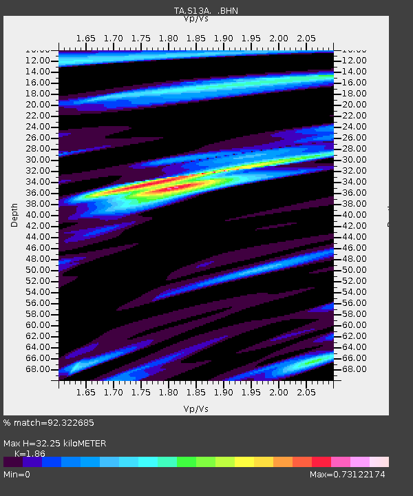
| Estimated Moho Depth: |
32.25 km |
| Estimated Crust Vp/Vs: |
1.86 |
| Assumed Crust Vp: |
6.194 km/s |
| Estimated Crust Vs: |
3.33 km/s |
| Estimated Crust Poisson's Ratio: |
0.30 |
|
| Radial Match: |
92.322685 % |
| Radial Bump: |
400 |
| Transverse Match: |
88.07321 % |
| Transverse Bump: |
400 |
| SOD ConfigId: |
2504 |
| Insert Time: |
2010-03-06 21:18:03.747 +0000 |
| GWidth: |
2.5 |
| Max Bumps: |
400 |
| Tol: |
0.001 |
|
Signal To Noise
| Channel | StoN | STA | LTA |
| TA:S13A: :BHN:20080626T21:30:53.10002Z | 25.705866 | 1.8204886E-6 | 7.0819965E-8 |
| TA:S13A: :BHE:20080626T21:30:53.10002Z | 7.027986 | 3.3401466E-7 | 4.7526367E-8 |
| TA:S13A: :BHZ:20080626T21:30:53.10002Z | 11.897731 | 5.091492E-7 | 4.2793804E-8 |
| Arrivals |
| Ps | 4.6 SECOND |
| PpPs | 15 SECOND |
| PsPs/PpSs | 19 SECOND |


