You are here: Home > Network List > CI - Caltech Regional Seismic Network Stations List
> Station MPM Manuel Prospect Mine, California, USA > Earthquake Result Viewer
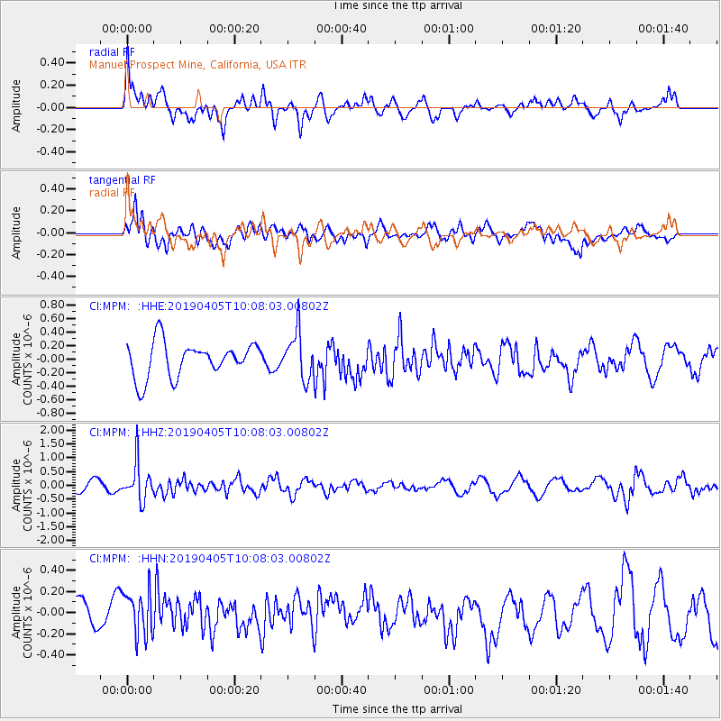
MPM Manuel Prospect Mine, California, USA - Earthquake Result Viewer
*The percent match for this event was below the threshold and hence no stack was calculated.
| Earthquake location: |
Southeast Of Honshu, Japan |
| Earthquake latitude/longitude: |
30.4/138.6 |
| Earthquake time(UTC): |
2019/04/05 (095) 09:56:53 GMT |
| Earthquake Depth: |
389 km |
| Earthquake Magnitude: |
5.8 Mww |
| Earthquake Catalog/Contributor: |
NEIC PDE/us |
|
| Network: |
CI Caltech Regional Seismic Network |
| Station: |
MPM Manuel Prospect Mine, California, USA |
| Lat/Lon: |
36.06 N/117.49 W |
| Elevation: |
185 m |
|
| Distance: |
82.7 deg |
| Az: |
52.48 deg |
| Baz: |
302.298 deg |
| Ray Param: |
$rayparam |
*The percent match for this event was below the threshold and hence was not used in the summary stack. |
|
| Radial Match: |
74.98775 % |
| Radial Bump: |
400 |
| Transverse Match: |
59.604244 % |
| Transverse Bump: |
400 |
| SOD ConfigId: |
13570011 |
| Insert Time: |
2019-05-02 21:16:51.262 +0000 |
| GWidth: |
2.5 |
| Max Bumps: |
400 |
| Tol: |
0.001 |
|
Signal To Noise
| Channel | StoN | STA | LTA |
| CI:MPM: :HHZ:20190405T10:08:03.00802Z | 5.3037124 | 6.841312E-7 | 1.28991E-7 |
| CI:MPM: :HHN:20190405T10:08:03.00802Z | 1.6290528 | 2.3038622E-7 | 1.4142343E-7 |
| CI:MPM: :HHE:20190405T10:08:03.00802Z | 1.3564845 | 3.4866457E-7 | 2.5703542E-7 |
| Arrivals |
| Ps | |
| PpPs | |
| PsPs/PpSs | |


