You are here: Home > Network List > TA - USArray Transportable Network (new EarthScope stations) Stations List
> Station V18A Ganado, AZ, USA > Earthquake Result Viewer
V18A Ganado, AZ, USA - Earthquake Result Viewer
| Earthquake location: |
Eastern Honshu, Japan |
| Earthquake latitude/longitude: |
39.8/141.5 |
| Earthquake time(UTC): |
2008/07/23 (205) 15:26:19 GMT |
| Earthquake Depth: |
108 km |
| Earthquake Magnitude: |
6.6 MB, 6.8 MW, 6.8 MW |
| Earthquake Catalog/Contributor: |
WHDF/NEIC |
|
| Network: |
TA USArray Transportable Network (new EarthScope stations) |
| Station: |
V18A Ganado, AZ, USA |
| Lat/Lon: |
35.71 N/109.93 W |
| Elevation: |
1977 m |
|
| Distance: |
80.2 deg |
| Az: |
51.514 deg |
| Baz: |
312.186 deg |
| Ray Param: |
0.048208937 |
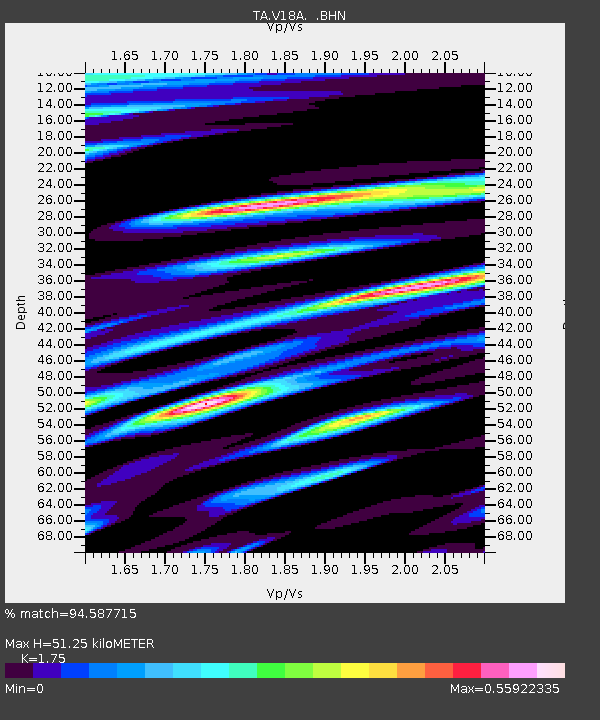
| Estimated Moho Depth: |
51.25 km |
| Estimated Crust Vp/Vs: |
1.75 |
| Assumed Crust Vp: |
6.496 km/s |
| Estimated Crust Vs: |
3.712 km/s |
| Estimated Crust Poisson's Ratio: |
0.26 |
|
| Radial Match: |
94.587715 % |
| Radial Bump: |
400 |
| Transverse Match: |
92.24016 % |
| Transverse Bump: |
400 |
| SOD ConfigId: |
2504 |
| Insert Time: |
2010-03-06 21:19:11.278 +0000 |
| GWidth: |
2.5 |
| Max Bumps: |
400 |
| Tol: |
0.001 |
|
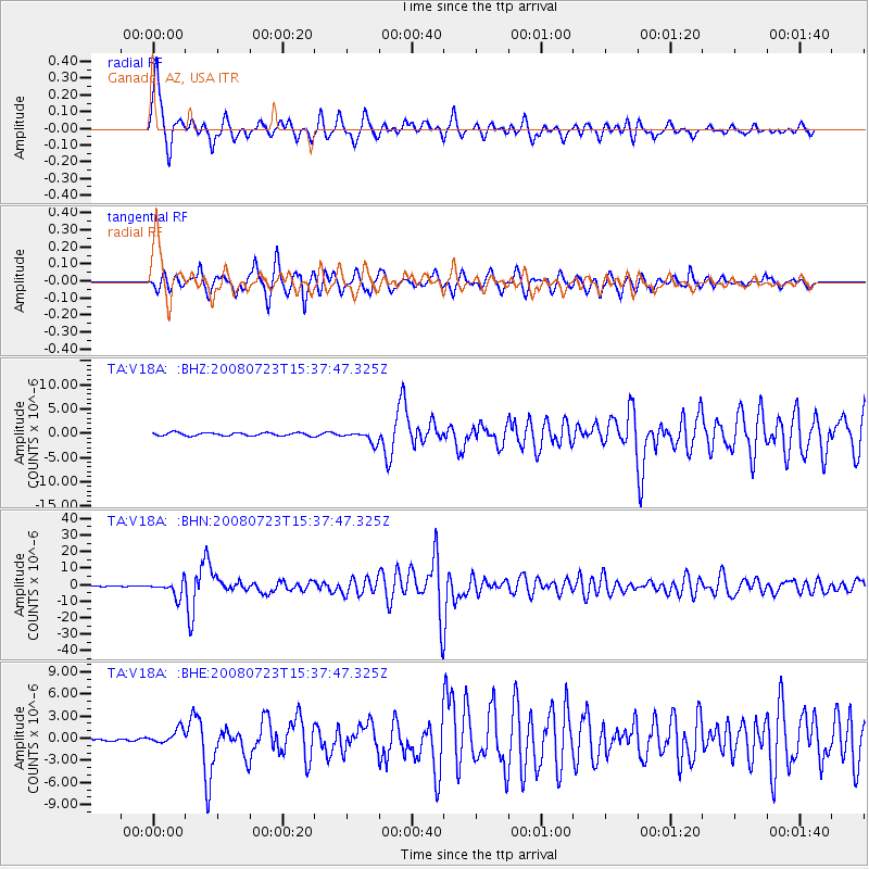
Signal To Noise
| Channel | StoN | STA | LTA |
| TA:V18A: :BHN:20080723T15:37:47.325Z | 41.71792 | 4.596457E-6 | 1.1017945E-7 |
| TA:V18A: :BHE:20080723T15:37:47.325Z | 9.689293 | 9.73145E-7 | 1.0043509E-7 |
| TA:V18A: :BHZ:20080723T15:37:47.325Z | 3.8342314 | 1.231931E-6 | 3.2129807E-7 |
| Arrivals |
| Ps | 6.1 SECOND |
| PpPs | 21 SECOND |
| PsPs/PpSs | 27 SECOND |


