You are here: Home > Network List > TA - USArray Transportable Network (new EarthScope stations) Stations List
> Station V18A Ganado, AZ, USA > Earthquake Result Viewer
V18A Ganado, AZ, USA - Earthquake Result Viewer
| Earthquake location: |
Southern Greece |
| Earthquake latitude/longitude: |
37.2/22.7 |
| Earthquake time(UTC): |
2008/01/06 (006) 05:14:20 GMT |
| Earthquake Depth: |
75 km |
| Earthquake Magnitude: |
6.1 MB, 6.2 MW, 6.1 MW |
| Earthquake Catalog/Contributor: |
WHDF/NEIC |
|
| Network: |
TA USArray Transportable Network (new EarthScope stations) |
| Station: |
V18A Ganado, AZ, USA |
| Lat/Lon: |
35.71 N/109.93 W |
| Elevation: |
1977 m |
|
| Distance: |
95.2 deg |
| Az: |
323.041 deg |
| Baz: |
36.142 deg |
| Ray Param: |
0.04080569 |
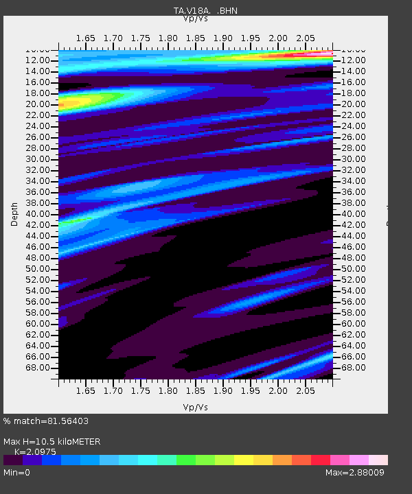
| Estimated Moho Depth: |
10.5 km |
| Estimated Crust Vp/Vs: |
2.10 |
| Assumed Crust Vp: |
6.496 km/s |
| Estimated Crust Vs: |
3.097 km/s |
| Estimated Crust Poisson's Ratio: |
0.35 |
|
| Radial Match: |
81.56403 % |
| Radial Bump: |
400 |
| Transverse Match: |
48.171955 % |
| Transverse Bump: |
400 |
| SOD ConfigId: |
2564 |
| Insert Time: |
2010-03-06 21:19:30.847 +0000 |
| GWidth: |
2.5 |
| Max Bumps: |
400 |
| Tol: |
0.001 |
|

Signal To Noise
| Channel | StoN | STA | LTA |
| TA:V18A: :BHN:20080106T05:27:03.849006Z | 2.0858314 | 8.217646E-7 | 3.939746E-7 |
| TA:V18A: :BHE:20080106T05:27:03.849006Z | 1.0730594 | 5.4819577E-7 | 5.1087176E-7 |
| TA:V18A: :BHZ:20080106T05:27:03.849006Z | 3.0894926 | 7.8329964E-7 | 2.5353665E-7 |
| Arrivals |
| Ps | 1.8 SECOND |
| PpPs | 4.9 SECOND |
| PsPs/PpSs | 6.7 SECOND |


