You are here: Home > Network List > TA - USArray Transportable Network (new EarthScope stations) Stations List
> Station V18A Ganado, AZ, USA > Earthquake Result Viewer
V18A Ganado, AZ, USA - Earthquake Result Viewer
| Earthquake location: |
East Of Kuril Islands |
| Earthquake latitude/longitude: |
46.9/155.2 |
| Earthquake time(UTC): |
2009/01/15 (015) 17:49:39 GMT |
| Earthquake Depth: |
36 km |
| Earthquake Magnitude: |
6.9 MB, 7.5 MS, 7.4 MW, 7.4 MW |
| Earthquake Catalog/Contributor: |
WHDF/NEIC |
|
| Network: |
TA USArray Transportable Network (new EarthScope stations) |
| Station: |
V18A Ganado, AZ, USA |
| Lat/Lon: |
35.71 N/109.93 W |
| Elevation: |
1977 m |
|
| Distance: |
68.0 deg |
| Az: |
60.997 deg |
| Baz: |
312.48 deg |
| Ray Param: |
0.05654105 |
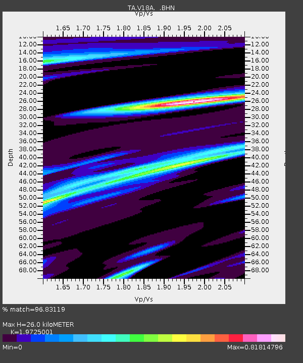
| Estimated Moho Depth: |
26.0 km |
| Estimated Crust Vp/Vs: |
1.97 |
| Assumed Crust Vp: |
6.496 km/s |
| Estimated Crust Vs: |
3.293 km/s |
| Estimated Crust Poisson's Ratio: |
0.33 |
|
| Radial Match: |
96.83119 % |
| Radial Bump: |
358 |
| Transverse Match: |
95.63017 % |
| Transverse Bump: |
396 |
| SOD ConfigId: |
2834 |
| Insert Time: |
2010-03-06 21:19:35.561 +0000 |
| GWidth: |
2.5 |
| Max Bumps: |
400 |
| Tol: |
0.001 |
|
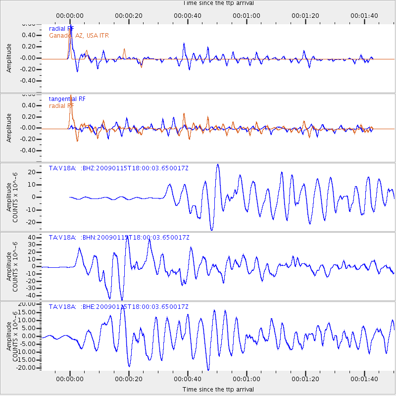
Signal To Noise
| Channel | StoN | STA | LTA |
| TA:V18A: :BHN:20090115T18:00:03.650017Z | 37.081554 | 1.1947679E-5 | 3.2220007E-7 |
| TA:V18A: :BHE:20090115T18:00:03.650017Z | 7.4152102 | 3.6708605E-6 | 4.9504473E-7 |
| TA:V18A: :BHZ:20090115T18:00:03.650017Z | 7.9729524 | 5.3599033E-6 | 6.722608E-7 |
| Arrivals |
| Ps | 4.0 SECOND |
| PpPs | 11 SECOND |
| PsPs/PpSs | 16 SECOND |


