You are here: Home > Network List > TA - USArray Transportable Network (new EarthScope stations) Stations List
> Station V18A Ganado, AZ, USA > Earthquake Result Viewer
V18A Ganado, AZ, USA - Earthquake Result Viewer
| Earthquake location: |
Sea Of Okhotsk |
| Earthquake latitude/longitude: |
54.2/154.3 |
| Earthquake time(UTC): |
2008/11/24 (329) 09:02:58 GMT |
| Earthquake Depth: |
492 km |
| Earthquake Magnitude: |
6.5 MB, 7.3 MW, 7.3 MW |
| Earthquake Catalog/Contributor: |
WHDF/NEIC |
|
| Network: |
TA USArray Transportable Network (new EarthScope stations) |
| Station: |
V18A Ganado, AZ, USA |
| Lat/Lon: |
35.71 N/109.93 W |
| Elevation: |
1977 m |
|
| Distance: |
65.0 deg |
| Az: |
63.296 deg |
| Baz: |
319.842 deg |
| Ray Param: |
0.056806352 |
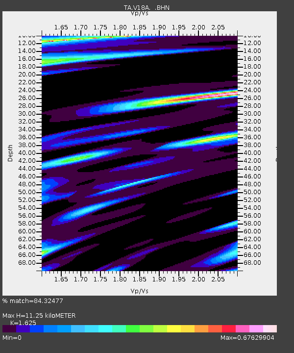
| Estimated Moho Depth: |
11.25 km |
| Estimated Crust Vp/Vs: |
1.62 |
| Assumed Crust Vp: |
6.496 km/s |
| Estimated Crust Vs: |
3.998 km/s |
| Estimated Crust Poisson's Ratio: |
0.20 |
|
| Radial Match: |
84.32477 % |
| Radial Bump: |
307 |
| Transverse Match: |
68.49996 % |
| Transverse Bump: |
331 |
| SOD ConfigId: |
2658 |
| Insert Time: |
2010-03-06 21:19:39.741 +0000 |
| GWidth: |
2.5 |
| Max Bumps: |
400 |
| Tol: |
0.001 |
|
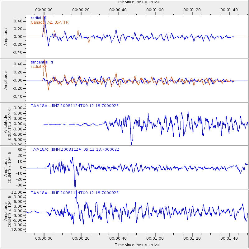
Signal To Noise
| Channel | StoN | STA | LTA |
| TA:V18A: :BHN:20081124T09:12:18.700002Z | 59.458733 | 4.052314E-6 | 6.815339E-8 |
| TA:V18A: :BHE:20081124T09:12:18.700002Z | 3.5112715 | 1.0596476E-6 | 3.0178458E-7 |
| TA:V18A: :BHZ:20081124T09:12:18.700002Z | 3.8904655 | 1.0707922E-6 | 2.7523498E-7 |
| Arrivals |
| Ps | 1.1 SECOND |
| PpPs | 4.4 SECOND |
| PsPs/PpSs | 5.5 SECOND |


