You are here: Home > Network List > TS - TERRAscope (Southern California Seismic Network) Stations List
> Station DGR Domenigoni Valley Reservior, California, USA > Earthquake Result Viewer
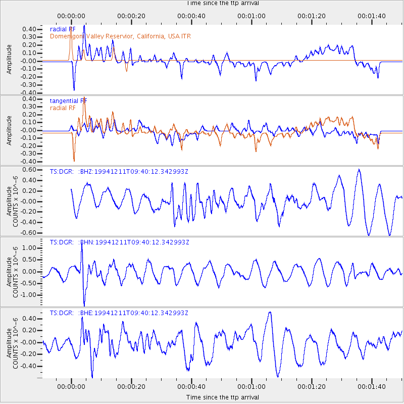
DGR Domenigoni Valley Reservior, California, USA - Earthquake Result Viewer
*The percent match for this event was below the threshold and hence no stack was calculated.
| Earthquake location: |
South Of Fiji Islands |
| Earthquake latitude/longitude: |
-24.9/-179.1 |
| Earthquake time(UTC): |
1994/12/11 (345) 09:29:01 GMT |
| Earthquake Depth: |
391 km |
| Earthquake Magnitude: |
5.5 MB, 5.6 UNKNOWN |
| Earthquake Catalog/Contributor: |
WHDF/NEIC |
|
| Network: |
TS TERRAscope (Southern California Seismic Network) |
| Station: |
DGR Domenigoni Valley Reservior, California, USA |
| Lat/Lon: |
33.65 N/117.01 W |
| Elevation: |
700 m |
|
| Distance: |
82.9 deg |
| Az: |
47.983 deg |
| Baz: |
233.987 deg |
| Ray Param: |
$rayparam |
*The percent match for this event was below the threshold and hence was not used in the summary stack. |
|
| Radial Match: |
70.611664 % |
| Radial Bump: |
400 |
| Transverse Match: |
44.19753 % |
| Transverse Bump: |
400 |
| SOD ConfigId: |
4480 |
| Insert Time: |
2010-02-26 14:10:06.537 +0000 |
| GWidth: |
2.5 |
| Max Bumps: |
400 |
| Tol: |
0.001 |
|
Signal To Noise
| Channel | StoN | STA | LTA |
| TS:DGR: :BHN:19941211T09:40:12.342993Z | 4.6150346 | 5.7361024E-7 | 1.2429165E-7 |
| TS:DGR: :BHE:19941211T09:40:12.342993Z | 1.7106261 | 1.9464832E-7 | 1.1378776E-7 |
| TS:DGR: :BHZ:19941211T09:40:12.342993Z | 1.2550157 | 2.0963418E-7 | 1.6703709E-7 |
| Arrivals |
| Ps | |
| PpPs | |
| PsPs/PpSs | |


