You are here: Home > Network List > TA - USArray Transportable Network (new EarthScope stations) Stations List
> Station F21K Alatna River, AK, USA > Earthquake Result Viewer
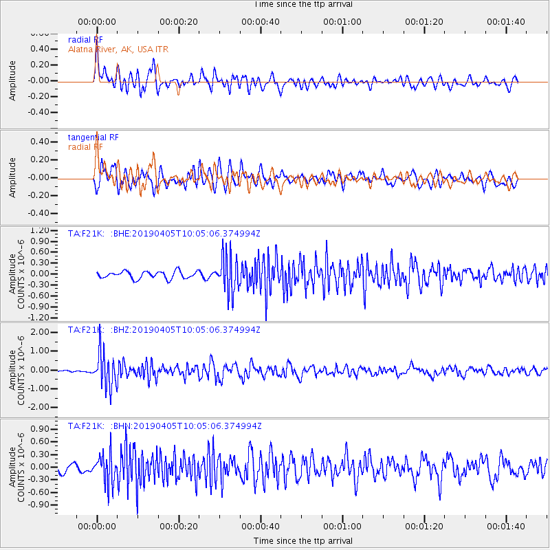
F21K Alatna River, AK, USA - Earthquake Result Viewer
*The percent match for this event was below the threshold and hence no stack was calculated.
| Earthquake location: |
Southeast Of Honshu, Japan |
| Earthquake latitude/longitude: |
30.4/138.6 |
| Earthquake time(UTC): |
2019/04/05 (095) 09:56:53 GMT |
| Earthquake Depth: |
389 km |
| Earthquake Magnitude: |
5.8 Mww |
| Earthquake Catalog/Contributor: |
NEIC PDE/us |
|
| Network: |
TA USArray Transportable Network (new EarthScope stations) |
| Station: |
F21K Alatna River, AK, USA |
| Lat/Lon: |
67.22 N/153.48 W |
| Elevation: |
597 m |
|
| Distance: |
53.8 deg |
| Az: |
26.564 deg |
| Baz: |
262.654 deg |
| Ray Param: |
$rayparam |
*The percent match for this event was below the threshold and hence was not used in the summary stack. |
|
| Radial Match: |
69.76373 % |
| Radial Bump: |
400 |
| Transverse Match: |
57.67254 % |
| Transverse Bump: |
400 |
| SOD ConfigId: |
13570011 |
| Insert Time: |
2019-05-02 21:21:46.691 +0000 |
| GWidth: |
2.5 |
| Max Bumps: |
400 |
| Tol: |
0.001 |
|
Signal To Noise
| Channel | StoN | STA | LTA |
| TA:F21K: :BHZ:20190405T10:05:06.374994Z | 11.861252 | 9.217367E-7 | 7.7709906E-8 |
| TA:F21K: :BHN:20190405T10:05:06.374994Z | 3.1380985 | 3.480373E-7 | 1.1090707E-7 |
| TA:F21K: :BHE:20190405T10:05:06.374994Z | 4.9225264 | 4.961488E-7 | 1.00791496E-7 |
| Arrivals |
| Ps | |
| PpPs | |
| PsPs/PpSs | |


