You are here: Home > Network List > TA - USArray Transportable Network (new EarthScope stations) Stations List
> Station G30M túh Zraii Njik, YT, CAN > Earthquake Result Viewer
G30M túh Zraii Njik, YT, CAN - Earthquake Result Viewer
| Earthquake location: |
Southeast Of Honshu, Japan |
| Earthquake latitude/longitude: |
30.4/138.6 |
| Earthquake time(UTC): |
2019/04/05 (095) 09:56:53 GMT |
| Earthquake Depth: |
389 km |
| Earthquake Magnitude: |
5.8 Mww |
| Earthquake Catalog/Contributor: |
NEIC PDE/us |
|
| Network: |
TA USArray Transportable Network (new EarthScope stations) |
| Station: |
G30M túh Zraii Njik, YT, CAN |
| Lat/Lon: |
66.98 N/136.22 W |
| Elevation: |
739 m |
|
| Distance: |
60.5 deg |
| Az: |
26.757 deg |
| Baz: |
278.662 deg |
| Ray Param: |
0.06011142 |
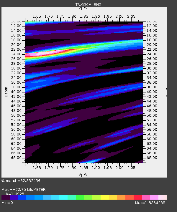
| Estimated Moho Depth: |
22.75 km |
| Estimated Crust Vp/Vs: |
1.69 |
| Assumed Crust Vp: |
6.522 km/s |
| Estimated Crust Vs: |
3.853 km/s |
| Estimated Crust Poisson's Ratio: |
0.23 |
|
| Radial Match: |
82.332436 % |
| Radial Bump: |
400 |
| Transverse Match: |
81.96175 % |
| Transverse Bump: |
400 |
| SOD ConfigId: |
13570011 |
| Insert Time: |
2019-05-02 21:22:00.866 +0000 |
| GWidth: |
2.5 |
| Max Bumps: |
400 |
| Tol: |
0.001 |
|

Signal To Noise
| Channel | StoN | STA | LTA |
| TA:G30M: :BHZ:20190405T10:05:52.850Z | 9.066382 | 2.8545746E-6 | 3.1485266E-7 |
| TA:G30M: :BHN:20190405T10:05:52.850Z | 4.908949 | 9.676385E-7 | 1.9711723E-7 |
| TA:G30M: :BHE:20190405T10:05:52.850Z | 6.021222 | 1.6005325E-6 | 2.6581523E-7 |
| Arrivals |
| Ps | 2.5 SECOND |
| PpPs | 9.0 SECOND |
| PsPs/PpSs | 11 SECOND |


