You are here: Home > Network List > TA - USArray Transportable Network (new EarthScope stations) Stations List
> Station V18A Ganado, AZ, USA > Earthquake Result Viewer
V18A Ganado, AZ, USA - Earthquake Result Viewer
| Earthquake location: |
Vanuatu Islands |
| Earthquake latitude/longitude: |
-15.4/168.6 |
| Earthquake time(UTC): |
2007/07/15 (196) 09:27:34 GMT |
| Earthquake Depth: |
8.0 km |
| Earthquake Magnitude: |
6.0 MB, 5.8 MS, 6.1 MW, 6.0 MW |
| Earthquake Catalog/Contributor: |
WHDF/NEIC |
|
| Network: |
TA USArray Transportable Network (new EarthScope stations) |
| Station: |
V18A Ganado, AZ, USA |
| Lat/Lon: |
35.71 N/109.93 W |
| Elevation: |
1977 m |
|
| Distance: |
92.1 deg |
| Az: |
53.645 deg |
| Baz: |
252.67 deg |
| Ray Param: |
0.041509114 |
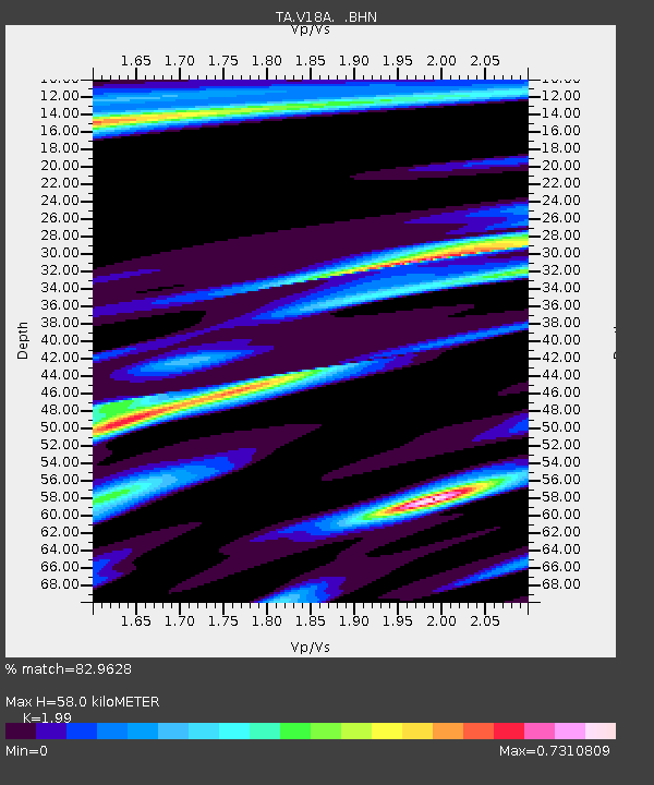
| Estimated Moho Depth: |
58.0 km |
| Estimated Crust Vp/Vs: |
1.99 |
| Assumed Crust Vp: |
6.496 km/s |
| Estimated Crust Vs: |
3.264 km/s |
| Estimated Crust Poisson's Ratio: |
0.33 |
|
| Radial Match: |
82.9628 % |
| Radial Bump: |
224 |
| Transverse Match: |
79.02149 % |
| Transverse Bump: |
400 |
| SOD ConfigId: |
2564 |
| Insert Time: |
2010-03-06 21:20:22.590 +0000 |
| GWidth: |
2.5 |
| Max Bumps: |
400 |
| Tol: |
0.001 |
|
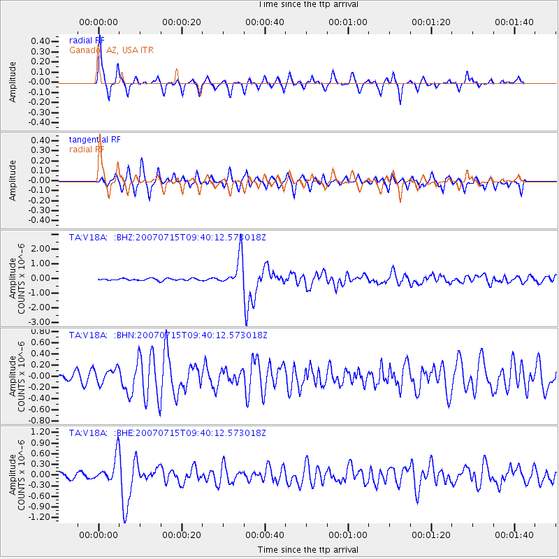
Signal To Noise
| Channel | StoN | STA | LTA |
| TA:V18A: :BHN:20070715T09:40:12.573018Z | 1.5640723 | 1.2854856E-7 | 8.2188386E-8 |
| TA:V18A: :BHE:20070715T09:40:12.573018Z | 3.2078674 | 3.7942428E-7 | 1.1827929E-7 |
| TA:V18A: :BHZ:20070715T09:40:12.573018Z | 15.988319 | 1.0781536E-6 | 6.7433824E-8 |
| Arrivals |
| Ps | 9.0 SECOND |
| PpPs | 26 SECOND |
| PsPs/PpSs | 35 SECOND |


